by Lisa Samson.
Ours is the only car in the Thruscross reservoir car park on this overcast morning. The towering spruce trees drip fat tears on our heads but the generous sweep of their canopy shelters us from the worst of the rain. The absence of indigenous varieties, such as ash and birch trees, is noticeable here, as if the foresters chose fast-growing conifers to create a plantation quickly. On the left, the path is straddled by nettles and cow parsley bedecked with curving Hollyhocks but on the right the rising waters have swallowed the bank. Tall grasses fan out on the surface instead of standing straight. Spruces hang forlornly over the water, their branches weighed down with moisture and their roots swollen with rain water intended for the lips of Leeds folk. The reservoir is wider and deeper than usual and even the imported sand on the far bank has been gobbled up.
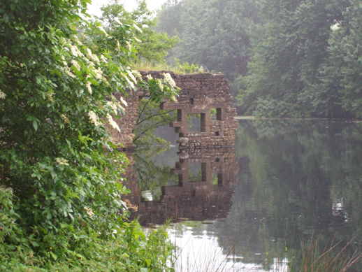
The remaining walls of West End Mill, an old flax mill, rise out of the water (see photo), a reminder that in the late 19th and early 20th centuries this was the site of a thriving weaving industry, sunk forever when the village of West End was flooded by the Yorkshire Water Authority in 1966. The walls are long and strong and the building must have been very tall. It would have housed many workers and machines and I try to imagine the clatter of spinning wheels powered by the great water wheel, but the only sound is the splatter of rain drops on water. We stare at the pattern of concentric circles on the surface, where a few swallows dip and dive. This place has a tranquility that is other-worldly and I fancy I can feel the presence of those others who dwelt here and went about their work over many generations.
A family of mallards float by, contented in the drizzle, and no wonder, because today the valley belongs to the birds. Across the great expanse of water, Canada geese are honking and flapping, disturbed by an exuberant dog. Two of them flap dangerously close to the dog, which retreats with its tail between its legs. These geese can be aggressive when protecting their young. A dark mass of rain clouds is bearing down on us and the ducks are now approaching the island of thick conifers that protrudes above the water. The reservoir splits into two channels that wrap like long crocodile’s jaws around the island, the last morsel of high ground that refused to be gulped down.
We follow the lower jaw of the reservoir as it courses into a river bubbling downstream over stones and vegetation. There is another crumbling building on the edge of the fields with wet lichen clinging to its crevices and grass growing from its open roof walls. We arrive at the remains of a road that appears to be going into the water, on its way to the underwater village. We cross a narrow footbridge where dragonflies hover over a stagnant pool and frogs spring for cover, leaving bubbles in their wake. Although most of the buildings were destroyed before the village was flooded, the stone bridge still remains under the water. This must be the greatest paradox of all: a bridge built to go over water now immersed by it.
We turn right and scramble up a boggy slope carpeted with pine needles. The scent of the wet pine resin is overpowering. There is a path up the road and over the fields but for some reason we always go this way. The tree tops are so tightly woven here that they close out all light and the gloom is affecting. I have walked here many times but never alone, unlike Swinsty reservoir further down the valley, which affords a lighter walk, unaffected by the weight of water burial.
Once above the trees, we begin the ascent to the moors above the reservoir. It is slippery here and the mud sucks at my boots; earth’s lingering kiss on my soles. Even on this summer’s day, the wind whips my hair and takes my breath away. After a short scramble we arrive at Springs Crag, a millstone grit rock formation with a distinctive layering similar to those found at Brimham Rocks, which were formed by glacial deposits 320 million years ago. There are many of these crags dotted around this area of Yorkshire. I lean against its slimy weight to eat my sandwiches and my son perches high on the top to survey the woods and valley below. We cannot see the reservoir from here; its spectral expanse temporarily hidden from view.
The earliest settlers here were Vikings who named the site after Thor, the Norse God of Thunder, the protector of humankind. The former village dwellers must have felt abandoned by him when they were forced to evacuate their homes in the mid 1960’s. Thruscross was the last of the Washburn Valley reservoirs to be created by the Yorkshire Water Authority to provide drinking water for the burgeoning metropolis of Leeds and Bradford. Fewston and Swinsty reservoirs are on the tourist trail and on Saturday and Sunday are often thronging with families. Not so Thruscross A little off the beaten track across the windblown moors of Nidderdale, it has a forlorn and neglected air.
‘Lisa Samson is a writer of fiction and creative non-fiction. Her work has appeared in Brand Magazine and A Wilder Vein, an anthology focusing on the relationship between people and places in the natural environments of Britain. Her first novel Talk to me was runner-up in the Virginia prize for Fiction 2011.’
