Words and picture: Matt Borne
Originally published 14 December, 2014 on Matt’s Wildwalker blog.
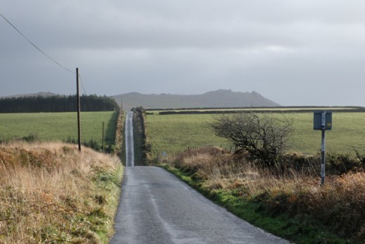
On Wednesday morning the radio was issuing dire warnings about a weather bomb. Western hills and mountains across the British Isles were going to experience very high winds. Just the excuse I needed to visit one of the highest points in Cornwall, Rough Tor on Bodmin Moor. My first encounter with Rough Tor was in 1994, and it keeps drawing me back. Its shape and r tor2distinctive granite rockpiles dominate the land around. Evidence of millennia of human activity lies all around, literally thick on the ground in hut circles, cairns, field systems, and settlements. It is one of the most atmospheric places I know. The experience begins with the drive in from Camelford along Rough Tor road, the last mile of which is surely the straightest lane in Cornwall. Making no concession to contour, it aims straight for the mid-point of Rough Tor so that as you approach it gradually and relentlessly fills your windscreen.
The wind is from the west and grows stronger as I climb. At least its in my back, pushing me up the slope. Westerlies usually carry some residual ocean warmth, especially in Cornwall where you are never more than twenty miles from sea. But the weather bomb has sucked down freezing air from the stratosphere and I quickly lose the feeling in the exposed parts of my face. Away to my right a pair of grounded ravens shelter in a field of shattered granite. The sky is a patchwork of flying grey clouds, with the low sun breaking through every few seconds making the light alternate between diffuse and gentle, and hard and sharp. Suddenly I have a shadow stretching north across the moor. It vanishes, then reappears. As I scramble up the last few feet of broken granite the wind strengthens and a gust shoves me across the flat turf of the summit. I huddle between two house-sized boulders, peering back the way I have come through a naturally formed tunnel.
The top of Rough Tor is dominated by granite rockpiles – massive discs of granite laid one on top of the other, appearing man-made but actually fashioned by horizontal weathering over millions of years. They were formed 300 million years ago, part of the granitic intrusion which stretches from Dartmoor to the Isles of Scilly. Hensbarrow Downs, better known as the china clay hills, come next in this line of granite upland, and are visible on the south western horizon.
I climb the leeward side of the most southerly rockpile, and braced against the gale that hits me, wedge myself into a large rock basin, formed by centuries of acidic rain reacting with the granite. These basins, like the rockpiles themselves, appear man-made and in folklore are associated with Druidical rites and human sacrifice. I get to work with my camera until my fingers become too cold to operate the controls. I inch my way off the structure, and as I prepare to jump the last five feet a gust blasts up through the funnelling boulders and for an instant holds all fifteen stone of me in mid air, before dumping me sprawling on the turf.
As I head back to the car I admit to myself that I underestimated the conditions. But I also feel very alive.