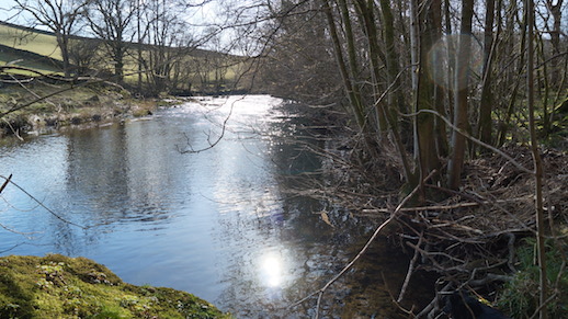
 Beck Mickle Ing woods
by Karen Lloyd
A river is many things to many people, but to me there is an extra quality to the rivers that have their birth in the mountains of Cumbria, and it is to one particular river that I find myself drawn time after time.
*
We bought our house in Kendal because of the view. Coming over from urban Gateshead and looking at this house with its view of those mountains, the birthplace of the River Kent, the decision seemed to make itself. It was only once we watched the removals men hefting box after box and sofas and beds out of the van and up the path that we realised the house was rather smaller than we remembered, so much had we been beguiled by the view.
The mountains of Kentmere are our barometer. Pulling back the curtains we can see winter’s first rimy frostings on the summits of Froswick, Ill Bell and Yoke, and later, when winter is properly underway, the first snow. We can see the high ground greening up in spring and summer, and be beguiled by the setting equinoctial sun; closing the curtains at the end of a high summer day, but staying a few moments to watch the last light fade from a roseate glow to a vibrant, crystalline blue.
I’d been brought up across Morecambe Bay in Ulverston and hadn’t properly left until my thirties. I left single and returned with a family. And so the river that issues from these hills has special significance in our lives; we cross it numerous times in our comings and goings and walk beside it on our way into town. A fifteen minute climb up the fell behind the house and the shape the River Kent makes within the landscape is visible; the valley head, the kink of the upper valley and the arm of crags and woodland where the river turns south. On the old back road to Staveley the Kent passes close to a litany of woods; Dorothy Farrer’s Woods, Spring Hagg, Mike’s Wood, Beck Mickle Ing and Craggy Woods.
The source of the River Kent is Hall Cove underneath Mardale Ill Bell. From there numerous water courses populate the valley head, a maze of tiny watery vessels, their passage witnessed only by ravens and a few hefted sheep. New streams come with the rains, (and it does knows how to rain here,) white lines stitching the hillside, visible from our windows. But before you know it the streamlets merge into a beck running over white and grey cobbles. Small waterfalls begin to form and the occasional rowan grows, leaning in as if listening to the watery chatter, and yolk coloured lichen covers rocks that border the stream.
The Ordnance Survey map shows well the art of place naming, though the significances and origins of some have become lost. The valley names belong in a highly localised vocabulary: Rainsborrow Cove, Green Quarter, Rowantree Knotts, Piked Howes, Withered Howe and Elf Howe to name but a few. The river gains momentum continually, the sound of it growing where it passes the sheltering knotty arms of Castle Crag and crashes in spate down Force Jump Waterfalls.
Onwards, and quieter meanderings along the valley proper. The Kent moves through the soft reedy pools of Kentmere Tarn where fishermen sit amongst the sheltered reaches, then moves on through the fields to unobserved places where trout lie quiet and meditative, unaware of the hooks that dandle on the surface upstream.
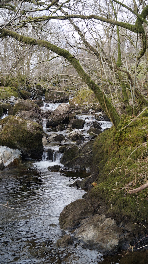 Below Force Jump waterfall, higher up the Kentmere valley
Ullthwaite Bridge is a good place for idling, for peering down into the clearest of clear waters, noticing the contrast between the shallows and the deeps, flinty grey-white rocks bordering sudden plunges into darker water. And what would childhood be without spending time around these small old bridges arcing over rivers? The playing of Pooh-sticks; “One, two, three – go!”, and never quite understanding how that stick never did reappear. Towards the village of Staveley the river pushes on between the airy heights of Reeston Scar on the western bank and Craggy Woods on the east. In Craggy, buttresses and slabs of rock combine with groves of ancient dark yew trees and monumental beech trees. It was up there that my son Callum, then twelve years old, had his first memorable encounter with mink. (And encounters with mink are usually memorable.) He was walking ahead of us with our friend, six foot four Harry and his bolshie dog, Ing. They stopped dead in their tracks – ahead two mink, blocking the path a mere metre away. The mink stood upright, and had the attitude of street corner dealers; even the dog became submissive. The two aliens eventually sloped off into the undergrowth and headed back down towards the river, having shown that fear was something they neither knew – nor needed.
After heavy rains you can hear the river talking. It sifts and sorts its stones mid stream – “donk – dunk… dunk…” The sound makes me smile, but at the same time I worry about what’s happening to our rivers, and how they cope, or will cope (although I am told they are designed to cope), with our modern deluges. In full brown spate the river courses over a favourite bank in Beck Mickle Ing woods and makes an island of the stand of trees and boulders, the place where younger son Fergus and his friends had a summer “look out post” over the river, clambering along the leaning trunk of ash above the water. There’s a stony beaches perfect for picnics, the place I tried – and failed – to teach our new collie how to swim. And of course the place for “plodging”, the name my family found for the ultimately time-wasting but absorbing art of chucking great cobbles into deep pools, listening for the simultaneous smack and thud as the stone connects with the water surface and makes its stately progress to the bottom, coming to rest amongst hundreds the same.
On the riverbank in Beck Mickle Ing ancient pollarded trees are like beached galleons at low tide. Numerous trunks rise upwards from an immense horizontal bank of growth and underneath this, one almighty stem connects each leviathan to the earth. Sometimes, after heavy rains they become isolated mid-river, like islands of gothic woodland architecture.
*
Just after we had moved, one of the first forays we made along the Kent was with a friend, a keen amateur naturalist. We walked north from Cowan Head through the fields and into a river-side meadow. We paddled and even attempted to swim, though the depth was hardly there. Then Brian started turning over large cobbles near the water’s edge. Within minutes he had a white-clawed crayfish, the indigenous species, in the palm of his hand, the mightily named Austropotamobius pallipes. If disturbed the crayfish gives an almighty kick with their antediluvian, articulated tails. If you’re careful you can take hold, and keeping your hand just above the water surface unfurl your fingers. In a flash the crayfish will thump its tail down into your hand and propel itself away.
Between Staveley and Burneside the river follows the course of the Dales Way. Come in March and early April to see the thick, buttery spread of small, pale wild daffodils in the woods and the water-side meadows. Come in May to Dorothy Farrer’s – come in the evening and wait for the light to enter the woods slant-wise, then watch the cobalt seams of bluebells light up and glow. Memories of summer bike-rides with my two boys when small nodding off in the seat on the back of the bike, or shouting out in excitement and frightening away the roe deer we’d stopped to watch, springing back into the woods from the middle of the meadow.
And we have otters. There’s film of them in the middle of town on YouTube – the female otter teaching her pups to hunt. My friend Katherine had never seen an otter. But one morning walking the path at the back of the police station, she saw her first – and it obliged by staying put for a fair few minutes. Another friend told me of an otter that had taken a fish from a fisherman’s line downstream at Sedgwick. Apocryphal or not, I admire the otter’s cheek. I worry about them though, after bouts of the unnaturally heavy rain we seem to have more and more these days. I wonder if their riverside holts will be washed out, and if they are, then where will they go.
*
On summer evenings through the open bedroom windows we sometimes hear the call of curlews heading upriver. They use the river as a map, navigating between their winter home on Morecambe Bay and their breeding places on high ground where they will mate and lay eggs in a grassy scrape. Sometimes, though infrequently, geese pass overhead. I hear them, then scan the sky to find them, the possibility of a thin, wavering line, high up and heading north to the Solway’s feeding grounds.
You can walk all day seeing nothing remarkable, and on other days it’s as if nature is showing off. A pair of buzzard and four young riding thermals over the top of Craggy Woods; a dipper teaching it’s young to take off, then gliding just under the water surface, emerging moth-like, quartering the river and alighting onto a white dipper-shit stained rock and making its characteristic dip, dip, dip gesture. Once a young buzzard caught dozing; it crashed out of its tree so close that I felt the wind from its panicked flight; so close that I saw the soft depth of tawny and cream feathers that, had I been able, I’d have liked to plunge my hand into. Another day – two green woodpeckers, a jay, oystercatchers. A kingfisher – larger in life than I’d expected. The flash of blue everyone tells you about. And there it is, but then there it isn’t……
One spring afternoon I’d been sitting under a small copse of rowan near the top of our fell, and from the south a lone osprey materialised, gliding over the rooftops. My eye followed it, the bird following the course of the river northwards until it disappeared over the mountains and on to the great track of High Street, the road over the mountains the Romans built. I supposed that it was one of the Bassenthwaite ospreys returning from wintering in Africa.
South of Kendal the river passes through a narrow limestone gorge and widens again at Sedgewick and then a short distance later its course runs past Levens Hall and the abstract, ancient topiary gardens. The final meanders cut jigsaw patterned pieces out of the flat farm lands of Sampool and Foulshaw, and finally the river ends its twenty mile run and emerges into Morecambe Bay. But the story doesn’t end here. In my lifetime the Kent has changed its course through the bay considerably. In my childhood it ran parallel to the coast by Kents Bank, but it has moved by nine miles or more in recent years to run close to Arnside. On a memorable visit out onto the bay with the sand-pilot, Cedric Robinson, we’d ridden four miles out on an ancient tractor to test the condition of the river ahead of two public crossing events. Cedric told me that after a bout of troubling heavy rains the Kent changed its course through the sands by six miles in one night. ‘It wasn’t like a river that day – more like a roaring sea.’
Over Christmas we’ve often had snow. But in 2010 the temperatures fell and stayed ridiculously low for weeks on end. On Christmas Eve we went down to the coast at Sandside to see for ourselves the thing that had people talking. We’d set off walking over the saltmarsh. Small groups of people stood at the edge of the land, quietly marvelling at Morecambe Bay brimful with ice-bergs. But these were no blue-white Arctic bergs; they were sand coloured, but more too, they were grey and dirty brown, flecked with alluvial mud brought down from the mountains. Mountains you can see from there at the coast, the familiar ridges of Froswick, Ill Bell and Yolk, the place the river begins.
The tide was coming in. It formed a glacial motorway of icy water. Every day the river brings parts of itself to be washed out across the bay and then washed back in again with the moon cycle. That day, as all days, the tide moved in unremittingly, curving in from the far side over by Meathop Mosses. But it was the sound of it as well as the sight that I remember; of millions of tiny particles of ice chinking and sloshing against each other and against the berg formations. The bergs were shaped like eroded sandstone rocks, layer upon layer where the tide had washed up higher and retreated again, forming night after frozen night. At the saltmarsh edges the ice had formed into delicate fan shapes, like collars from Elizabethan costume. As the sun began its mid-winter descent into the west, the light caught the lacy edges turning the ice into jewelled fancies. I looked closer and saw the familiar grey and brown and silver; the river had stitched itself into the ice like dull sequins and tiny beads. On that day, as on so many others, I was in awe of all that the Kent is, and all it can be.
Karen is a writer of creative non-fiction and poetry based in Kendal, Cumbria. Her first book, The Gathering Tide; Walking the Edgelands of Morecambe Bay contains writing on land, landscape and memory, and will be published end 2015/early 2016 by Saraband press. You’ll find her website HERE.