 Words and pictures: Brian Lewis.
An earlier version of this piece was posted on The Halt in March. Many thanks to Brian for allowing us to repost.
A mile of coast, leasehold and freehold, blocked out in the west, clean lines along the flat sheet. To the south, The Willows; to the north, Withernsea Sands. The park is not a public park, it is a retirement camp, hedged and fenced, orderly plots, concrete stops the drift into the back country. The centre of the camp is left blank. The caravans look through the town, facing front, letting go of the east. A mile of sands, staked from end to end: the stakes make up the groyne fields, every hundred yards a forced beach, timber sticking out of the sea wall into the sea. It is the town’s measure and protection. At the north end, as Waxholme Road is drawn inland, the waves sink the timbers, the waves sink the field lines. The town doesn’t move. Another camp is settled next to Withernsea Sands, Seathorne, an overspill, the camps divided by Waxholme Road. Seathorne is not on the town plan and has no revetments to the east. For every position held by a caravan, two lie vacant: grey-green gaps where the chassis used to rest, a caravan’s width between them. It is not enough to make rank.
The town falls back, its mass pressing into the south. Above it is the village of Waxholme, then the village of Tunstall; fields laid to either side, their borders drawn from the course of the Tunstall Drain. The drain flows east to west, its head tucked behind a coastal embankment, fresh water shielded from salt water. On the other side of the embankment, one hundred yards north of the drainage head, two hundred yards south-east of a holiday park, the land softens and crumbs. Here, between the cliff’s edge and the sea’s edge, stood the last sign of longitude before the North Pole. Tunstall’s meridian mark was recycled from a nearby trig point, authorised by the Ordnance Survey in 1999, when it became clear that the ground beneath the point was about to fall into the sea. The new meridian mark was sited a few yards from the cliff edge at Tunstall, until 2003, when the last yard shrank and the mark yielded to the beach. By 2008, nothing could be seen of the pillar. Nothing points to it, or to the villages east of it, the villages of Dimlington, Northord, Newsham, Monkwike, Sunthorpe, Waxholme, Orwithfleete, Owthorne, Burstall, Hoton, Turmarr, Old Kilnsea, Old Withernsea, Ravenspurn, Ravenser Odd, the villages caught between tides.
Between the late medieval period and the early twentieth century, the Holderness coast gave the sea more than twenty settlements for burial. Among the first of these was Sand le Mere, near Tunstall, washed from the cliff-line before the Domesday Book was completed. Though the village is long lost, the name remains in use, claimed and reclaimed over the centuries, the site and the spelling shifting by degrees. By 1622, a coastal bank has been raised for the protection of the hollow of Sandley mere: the bank is frequently damaged at high tide. An enclosure act for the land around Tunstall, passed in 1777, removes the mere to the south-eastern edge of the parish, bounded by drain and close, cut off from common meadow and common pasture. In the 1820s and 30s, Sand le Mar is repeatedly raided: not by the sea, but by residents of neighbouring villages, removing sand and pebbles from the beach to repair their roads. The weakening of the shore continues through the second half of the 19th century, with the extraction of gravel and cobbles by agents of Sir Thomas Constable, Lord of Holderness, estimated at several hundred tons for the winter of 1868. The Lord’s rights over the foreshore were established in the 15th century; the tolls were maintained by rank.
From the shore, the head of Tunstall Drain appears as a wide breach in the cliff, breaking the vertical plane, steep lines receding to flat country. After the invasion of France and the Low Countries by Germany in May 1940, the Holderness coast, with its proximity to Hull and other industrial cities, was viewed as a likely target for an amphibious assault: it offered several access points for tank landings, foremost of which was the drain outlet at Tunstall. Over the summer of 1940, the outlet and its flanks were steadily fortified by the introduction of weapons pits, pillboxes, fire trenches, anti-tank ditches and anti-tank blocks. The concrete blocks, made with sand and shingle from Sand-le-Mere, were laid in single rows at the north and south ends of the beach, running into the sea, and in double rows parallel to the drain outlet. Near the cliff’s edge, scattered along the ditch and field lines east of Tunstall Hall, 18 Nissen Huts sheltered a hidden garrison. Further inland, 100,000 concrete posts were erected in the fields behind the tank traps, intended to block the descent of troops borne overland by gliders. The tanks and the gliders never came. The garrison has been replaced with a caravan park. The posts have been recycled as kerbs for private driveways. The blocks sink into the sand and shingle.
North of Tunstall, north of the old minefield, now reverted to pasture, is a crumb of land called Monkwith. The name is an approximate marker for Monkwick, or Monkwike, a hamlet lost in 1841. The old enclosures and outlying farms have gone over. There is nothing of Monkwith but road, downgraded to a coastal track as more holes appeared in the cliff, the track now closed to vehicles at both ends: gates, bollards, earth barriers. Here and there the track breaks off, then starts again, the line of the road floats in the gap, joined up from memory. Three fields east of the track is the church of St Margaret, twice rebuilt since the 12th century, most recently in 1956, fifteen years after the church was bombed. The fields have closed over the damage. Two fields north-west of the church is Admiral Storr’s Tower, built in 1750; the octagonal stone and brick structure was intended as a look-out, then, in 1794, served as a military hospital for troops from the coastal encampments. Both church and tower are visible from the cliffs; the tower is also visible from the sea, and, for many years, aided mariners in their navigations. It has since fallen out of use and is retained for heritage. Now, the tower surveys the drift and wreck in the cliff itself, spreading westward over lane and field, eight sides of dressed stone, eight winds falling.
The coast picks up without its path, pushing past Grimston, Garton, the glebes, the little garths. The farm buildings keep their distance from the cliffs, arable fields set to the east: the field boundaries stripped of trees, hedges, vegetation, the cover collapsed, the planes exposed. The regulation lies within the fields, not between them, tight, orderly rows of wheat, oats, beans, only the right-hand margin torn up, the crops spilling over, ragged new edges in the boulder clay. There is nothing to hold it back. The coast lifts towards Beacon Hill, unsettled in its shadow, clumps becoming beach. The hill, once crowned by three beacons, then two, then one, is now capped by a pillbox, the cliff closing in. As the hill drops, it crumples, unable to support itself or the concrete. There is no threat from the sea, its blank noise, its unbroken surfaces. Towards East Newton, the crust puts out more cavities: the last of Ringbrough, its farm and outbuildings, on a long slide to the shore, rubble and rust, half on land, half off, pillboxes in reach of the tide. During the Second World War, the 18th century farm became an artillery battery: a brick observation tower was added to the existing structures. The tower lies flat against the horizon, staring back at the cliff, the old camp, bearings washed out, unburied.
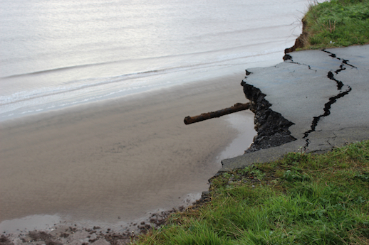
The road pulls west from East Newton, the new town, once, behind it the last byway north, splitting the settlement, sparing the estates on the left turn, looking away from the short manorial drive, the manor in its crook, the faithful huddle at the drive’s end. It doesn’t recover the coast for another two miles, a mile inland to the village of Aldbrough, then a mile out along Seaside Road, scraping a small leisure park and a large caravan park. The junction of Seaside Road and Campsite Road marks, or marked, the site’s eastern perimeter; the perimeter has been taken in, the junction parting with it, dropping the end of Seaside Road into coarse steps. The steps show the road in section: tar, aggregate, binding, sub-base. A pipe, or rod, extends a few yards out of the fracture, aiming north-east from the headland, the point breaking off. Below it, scraps of camp litter the cliff-face. Behind it, the concrete foundations of fifteen caravan pitches, the caravans gone, the bases blank. There’s no sign of the labour that cleared them. The cliff is not sheer, the rough slope takes its time to meet the sand, there are obstacles, there is no advance from the tide, there is no debt to the long fetch.
Near East Hill Farm, another road is written off, there are blocks, round and hollow, there is signage in all directions. The road doubles back on itself, towards Withernwick, towards a fixed barrier, corrugated metal stretched across the road’s width, the verges and the hedgerow, it is low and doesn’t quite settle on the levels. This is not civilian work. A few miles ahead, to one side of Withernwick, three pale spindles, seemingly idle, then six, then nine, grazing the sky, harvesting air. Withernwick, white thorn of farmsteads. The turbines fill more of the cloud-line then vanish in the bends. The road, now a track, straightens again, the ground firming up on both sides. On the south side, an orange van, parked between the track and what appears to be a fallow, featureless field. A wind moves over the field, disturbing its colour: dozens of small red flags, irregularly planted, some in clusters, some in isolation, each one caught in a wave. The flags have details, these have been memorised, one reads N.E. CORNER, black script on the plastic, blue paint scored into the soil, every position marked and abandoned. And traces of the ministry all along this track: the white crosses, the white ribbons, the distant smoke.
Withernsea to Hornsea
12 May 2014
Brian Lewis is the editor and publisher of Longbarrow Press. His limited edition pamphlet, East Wind, will be available from Gordian Projects in October 2015. Visit Brain’s website and follow him on twitter.