The latest in a series of posts following Tom Bolton – author of London’s Lost Rivers and London’s Lost Neighbourhoods – as he travels the British Isles. This month, a diversion to Wiltshire.
When we reached the Essex county boundary, on the River Stour outside Manningtree, in June 2017, we thought our year-long coast walk was finished. But we soon realised we had unfinished business. The Foulness Ranges, closed for military exercises after the Manchester and London terror attacks, occupied seven miles of the Essex coast, an entire island of low-lying salt marsh and farmland now firmly off-limits. With no possibility of reaching the tidal Broomway coast path, our Essex journey had a gap. Instead, we decided to explore the territory by proxy, visiting military structures and landscapes where we could find a way in. A few weeks later we found ourselves at a music festival in the Kelvedon Nuclear Bunker, outside Brentwood.

Until the 1990s Kelvedon was regional government headquarters for South East England, the destination for a chosen few in the event of a nuclear attack. After decommissioning it had become an unlikely, family-run tourist attraction. Concealed in woods north of Brentwood, a 1950s bungalow was a sham – cover for a long tunnel leading deep into the side of a hill. At the other end were three levels of heavily reinforced underground chambers, with a room set aside for the Prime Minister, and desks for military commanders and civilian coordinators, all fitted out with mid-90s screens and fax machines. Essex was the refuge if and when society collapsed. The bunker now featured a souvenir shop selling polished gemstones and novelty handcuffs. The music, bouncing around concrete bunkers and generator rooms, paid tribute to the era of early synthesizer experimentation, music from the bunker’s heyday. Snooker legend Steve Davis was spotted in the control room. The setting was perfect, and electronic sounds seemed to emanate from the structure itself. Kelvedon had been comprehensively reclaimed, and was sending its slow vibrations deep into the Essex soil.

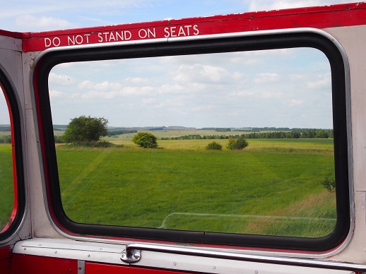
Soon afterwards, we discovered an annual open day at the military village of Imber, on Salisbury Plain, and booked ourselves on a train to Warminster. Imber was a ghost village, stranded on the Ministry of Defence firing range that occupied the downs above Warminster. An isolated village of 150 people, it had been evacuated in 1943 during preparations for D-Day. The occupants, given six weeks to pack, were never allowed back except to be buried in the churchyard. Imber had remained off-limits for 75 years with the exception, oddly, of an annual visit from a troop of bus enthusiasts. Once a year the 23a bus route from Warminster to Imber was resurrected, served by a collection of new and old Routemasters brought in from London, and a stray open-topped tour bus from Bath.
On a slow train from Waterloo, it became apparent that a high proportion of passengers were heading for Imber. Most appeared to be bus enthusiasts of retirement age, dressed for all weathers and shod for climbing the demanding Routemaster stairs to reach the view from the top deck. At Warminster Station we siphoned into a supply of London buses driven, presumably, by busmen on holiday. Soon we were among army housing and depots as the road rose along a ridge and passed through a checkpoint, unmanned for the day, and on to the open downs.
The downs were a distinctively Wiltshire landscape, smoothed, rounded and unmistakable. The scenery was first millennium BC, and the fortifications of Battlesbury Hill reared to the south. Julian Cope, in his Modern Antiquarian guise, claimed that despite the exposed location this would have been his favourite spot if he had lived here in the Iron Age.
The landscape was wide open and undulating, familiar but nevertheless not quite right. Meadows, unfarmed since the Second World War, were lush with wild flowers. They offered a glimpse of the pre-industrial farming past, a lost agrarian Britain sprayed into submission across much of the south. Boreham Down, Bishopstrow Down, Summer Down, South Down Sleight were time slip territory, diverted on to a parallel path. This was the territory of the Great Bustard, a turkey-like bird native to Salisbury Plain, hunted to extinction during the 19th century. It had been reintroduced in the 2000s, and now lived in undisclosed downland locations. The public were encouraged to steer clear, because the birds were so heavy that taking off in fright burned up huge amounts of energy.
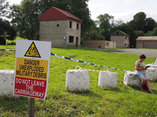
But it was not just the eerily untouched downs that told a strange story. On the hillside, rusty, burned out tanks could be seen abandoned among the bushes. The only people in sight were groups of bus spotters, waiting in lay-bys to snatch vintage Routemaster shots. The landscape was deserted, but a violent, prolonged conflict had left its traces on the ranges. Tank tracks churned the mud, and signs warned of explosives lying undetonated away from the road. This alternative version of Britain, like the invasion scenarios of films such as ‘Went the Day Well’ had been at war and perhaps still was. Meanwhile, the territory was managed by the sinister-sounding Landmarc Security Solutions, the privatised operation in charge of the downs.
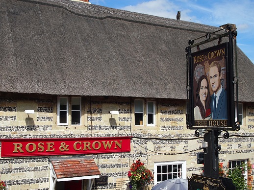
The bus routes and timetables were remarkably involved for a day trip, an authentic Transport for London experience carefully recreated in rural Wiltshire. It was possible to spend an entire day en route to ghost places that barely existed. In the middle, surrounded by army ranges and dominated by a camp, the village of Tilshead seemed hallucinatory and the Rose and Crown featured an alarming William and Kate pub sign.
The remote upland setting of Salisbury Plain was Imber’s downfall. The village’s isolation made it easy to requisition when US troops needed training space to prepare for the invasion of Europe. The villagers were told they would be allowed to return after the war, but as the decades passed they found themselves fighting the Ministry of Defence for the right just to visit their former homes. Increasingly, these ceased to exist as the army dismantled what had been, from the poignant photographs of pre-war thatched cottages, a pretty village. Ordnance Survey maps of the 1920s mark several farms, a smithy, a school, a vicarage, the Bell Inn, an Elizabethan manor house (Imber Court), a Baptist Chapel (Particular), a war memorial and St. Giles Church, on a low hill above the only street.
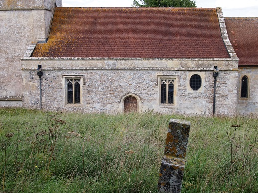
For an abandoned village, Imber was crowded and St. Giles surely the busiest country church in Britain for a day. It jostled with visiting bus enthusiasts and retired Transport for London staff, but the surrounding village was hollowed out. The timbered houses had been replaced by shells with gaping windows and doors, used by the army to practice street warfare. Imber’s buildings had been systematically torn down and replaced, and little was left of the original village beyond the church. Even so, the evicted inhabitants had carried on fighting the Ministry of Defence until the 1970s, when their campaign to return was finally rejected.
On the return journey, the view from the open top deck of the tourist bus revealed low mounds beside the road, fenced off from tank manoeuvres. These were barrows, and the landscape was dotted with them. The Ordnance Survey map identified a remarkable array of obscure Iron Age features on the firing ranges. There were long barrows, earthworks, strip lynchets (farmed terraces), settlements, field systems and tumuli. There were also pillow mounds which dated from much later – artificial warrens for rabbit farming, built after the Normans introduced rabbits to Britain. The downs were alive with the marks of Imber’s ancestors, and their latent presence was strong.
Wiltshire was a long way from the Essex coast, but a dominant military presence connected the two. Much of Salisbury Plain had been army land for generations, and at both Imber and on Foulness the ordinary life of these places was fading beyond living memory. Large areas of Britain were frozen in the first half of the 20th century. Access was controlled by military security and, as a result, few noticed or visited them. A shadowy Britain was only occasionally illuminated, giving brief glimpses of landscapes that seemed both familiar and strange.
*
On Wednesday 27 September, to mark the publication of his latest book, Camden Town: Dreams of Another London, Tom is leading a walk looking at Camden’s culture and history, closing with a special book signing event at Waterstones in Camden. Details here.
See previous Edge Walking posts here.
Tom Bolton on Caught by the River/on Twitter