Tolls, prostitutes, and long-distance swimming competitions: Helia Phoenix delves into the history of Cardiff’s Clarence Bridge
Ah, autumn in Wales, when the weather is an endless slap in the face. When the Taff tosses and sulks, swollen from all the extra swag gathered on its journey through the south Wales valleys. The loot is considerable: balls snatched from the mouths of careless dogs; lunch boxes; bits of tarpaulin; rusting cans of Tennent’s Super. All manner of random crap carried downstream. Eventually, it all comes out in the wash – the wash underneath Clarence Bridge, the bland, “modern” concrete structure that bonds the neighbouring wards of Butetown and Grangetown in Cardiff.
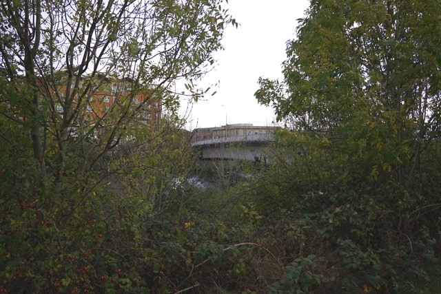
Clarence Bridge, peeped through undergrowth from the Taff Trail
This bridge has served various purposes for me over the years. It’s the foundation of the cycle commute to work: the point where my muscles steel for the journey ahead or sigh with relief at being so nearly home. A few years ago, during my early courting days with a young man, we had a “massive” night out in town that ended in a long, inebriated, igam ogam (Welsh for zig zagging) wander back from the city centre. As we got to the bridge, he projectile vomited over the fence at its edge. The offending puke was high in volume and great in velocity, and I don’t think I’ve ever laughed quite so much. (Heartwarming postscript to that story: that young man and I have been together ever since).
Before the 1890s, a wooden swing bridge stood near here, connecting Victorian suburbia with the busy industry of the docks. The landscape then was completely different: much of modern Butetown didn’t exist (including my street, which only appears on maps published from 1898 onwards). The wooden bridge, originally built in 1861, was privately leased by the Taff Vale Railway Co, who introduced a toll on the bridge to profit from the increasing numbers of jobbing dockers using the bridge to get to work. Working men were charged a penny for walking over the bridge, or more if you had animals or were in a carriage.
In response, the local Grangetown community did the only things it could: it held demonstrations and rioted. On the first day of the toll, a mob lifted the gate off its hinges and threw it in the river. Residents started taking the long route to work to avoid the bridge, or caught the tram to avoid paying the toll. Some enterprising locals tried to start a halfpenny ferry service to undercut the Railway Company. After families started to leave the area in further protest, the Cardiff Corporation stepped in and built the Clarence Road swing bridge, which was opened in 1890 to much fanfare and celebration.
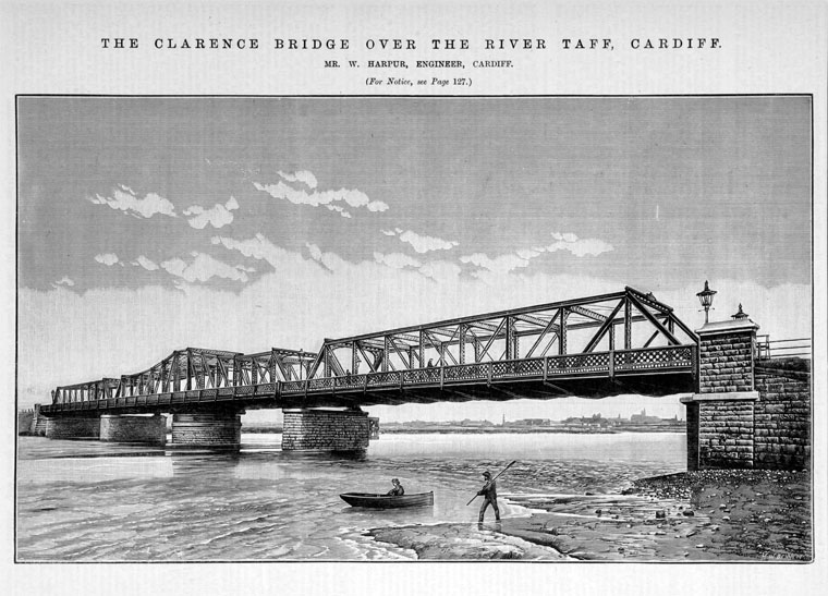
Original design drawing for Clarence Bridge by engineer William Harpur, from Grace’s Guide
The new bridge (named after the Duke of Clarence) carried trolley cars numbers 6 and 9. The cables had to be disconnected before the bridge could swing to let boats pass by. I think this seems like a weird thing to put on a postcard, but it gives a nice snapshot of the street scene at that time.
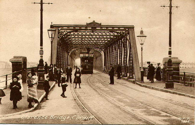
Clarence Bridge, 1908. Image from Movable Bridges
For some time, Clarence Bridge marked the end point of the Taff Swim, aka the Long Distance Swimming Championship of Wales. The event started near Cardiff Castle, and was held over this stretch of the Taff between 1924 and 1930. Despite the river running black with coal dust from the pits in the valleys, this event was incredibly popular and only moved to the much cleaner Roath Park Lake when Cardiff Bridge had to be rebuilt in 1931. The Native Ladies winner in 1924 was Kathleen Thomas – a local swimmer from Penarth who, in 1927, would become the first person, male or female, to swim the Bristol Channel (she was only 21 when she did this).
My favourite story about the bridge comes from the wonderful Grangetown Cardiff’s detailed history section, which I highly recommend. It’s a thorough snapshot of a typical British parish developing through the 19th and 20th centuries.
        OCTOBER 1908: The darker side of Cardiff was getting attention, with claims
        that prostitution was getting out of control ... George Bibbings wrote to the chief
        constable and the Echo, saying it was clearly evident that there was a "brothel colony"
        on the route from Tudor Street to Clarence Embankment. Prostitutes "and their
        partners in vice" were using the trams, with the full knowledge of the conductors,
        claimed Mr Bibbings.
Although proud Docks folks these days will scold you for sharing these salacious titbits, there’s more than just one account of houses in the area being used for prostitution and other general naughtiness. It’s easy to see how: all the houses along Clarence Embankment (which meets Clarence Bridge on the Butetown side) have huge basements, which run the entire length of the houses, accessible only from the kitchens out the back. One of my neighbours remembers their basement entrance being bricked up when she moved to the street as a child in the 50s. Her father took a sledgehammer to the wall and found an entire Mini reconstructed down there (though not in working order). It was rusted beyond repair, so she and her brothers spent the summer smashing it up and ferrying it piece by piece out of their house.
“Dens of iniquity” along Clarence Embankment
I realise I shouldn’t romanticise those days. But who wouldn’t long to witness them? In my mind, each basement along the street held a gambling hole or illegal drinking club. Come the early hours of the morning, all manner of humanity would stagger out, bleary eyed, heading back across the bridge from these dens of sin into suburbia, and to the families that were waiting angrily for them to come home.
The original Clarence Road swing bridge was demolished in 1975, when it was replaced with the current structure. Compared with its predecessor, it’s pretty bland.

Clarence Bridge, looking from west to east: from Grangetown into Butetown. (The vomit incident occurred over the fence to the right of the picture, in case you’re interested)
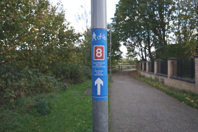
These days, the bridge forms part of the Taff Trail, which links Brecon to Cardiff. It’s also the arse end of National Cycle Route 8, known as the Lôn Las Cymru, which links Holyhead on Anglesey with Cardiff Bay.
On the day I head out to take the photos for this piece, it’s windy and bright. I say hello to the friendly Irish pensioner who lives alone on my street. In the gutters, I step over a disused bike tyre: a charcoal halo over a dirty scrum of leaves.
The bridge carries an endless froth of streamlined cyclists and efficiently dressed hikers, heading east and west. They weave in between the smartly dressed city women and men, who – like the working stiffs a hundred years ago – use the bridge to head from Grangetown for jobs in the Bay, although the employment circumstances are completely different. Cardiff Bay’s heavy industry has disappeared, so people head instead for call centres, or to serve food or drinks, or to the National Assembly. Teenagers in oversized coats also use the bridge, heading for the sleek tower of glass that is Cardiff and Vale College, recently opened on Dumballs Road. Because today, the bridge leads you to devolution. Education. Blocks of flats. A thousand wifi networks between here and your office. It leads to Butetown, the dried up husk of what you’d know as the docks, or Tiger Bay. It’s a far cry from the days when the river flowed black, into endless acres of salt marsh, and men refused to pay the penny toll.
*
Helia Phoenix has written for Rolling Stone, The Guardian, and Kruger Magazine, and now runs the We Are Cardiff project. The previous instalments of her column can be found here. You could also take a peek at her website or follow her on Twitter, if you felt like it.