Atlas of Vanishing Places: The lost worlds as they were and as they are today, published by White Lion, is the latest book from Travis Elborough, with maps by Martin Brown. Read an extract from the ‘SKIPSEA, YORKSHIRE’ chapter below.
Ravenser Odd was once a name to be reckoned with, as you might expect, while savouring its fruity mix of vowels and consonants. Situated on the sandbanks of the River Humber at the entrance to the North Sea near Spurn Point on Yorkshire’s east coast, it was a major fishing and shipping port with a harbour and quay, warehouses, boatyards, a market place, a prison, a chapel, taverns and all the amenities a medieval town could offer those engaged, to varying degrees of honesty, in maritime trade. In the thirteenth century it surpassed its nearby neighbours Hull and Grimsby in economic importance. So keen was it to retain a lead over these ports, its pilots became notorious for forestalling – a means, sometimes fair but more often than not foul, of encouraging merchant ships bound for its rivals on the Humber to initially dock with them. This sharp practice allowed Ravenser Odd merchants to claim first dibs on any cargo, and its chandlers and shipwrights the business for repairs.
When the story of this town later came to be told, some would see divine retribution in its eventual fate; the Lord appearing to take such a dim view of Ravenser Odd’s nautical finagling that he commanded the sea to wipe it off the earth. God sanctioned or not, in the 1340s the sandbanks on which it stood shifted and many of the houses were swept away. By 1355 more than two thirds of the town lay under water and the majority of its inhabitants had abandoned it. Seven years later, a terrible storm known (with almost pitiful literalism) as the Great Drowning of Men raged across the east coast and carried what little else remained of Ravenser Odd into the sea.
Over twenty other towns and villages standing along this stretch of east Yorkshire –the Holderness coast that runs from Flamborough down to Spurn Point – have fallen into the North Sea since the Middle Ages. Such has been the pace of coastal erosion in this part of England that some now lie 31⁄2 miles (6km) offshore. In a survey of these departed settlements published in the Yorkshire Archaeological Journal in 1952, the local historian M.W. Beresford, succinctly gave the single word ‘drowned’ as the explanation for the loss of Cleeton, a one-time south easterly neighbour to Skipsea. And unless urgent action is taken, the seaside settlement of Skipsea, with its caravan parks, clifftop chalets and bungalows, looks set to follow Cleeton, just as Cleeton followed Hyde, the port just to the north of it lost over six centuries ago.
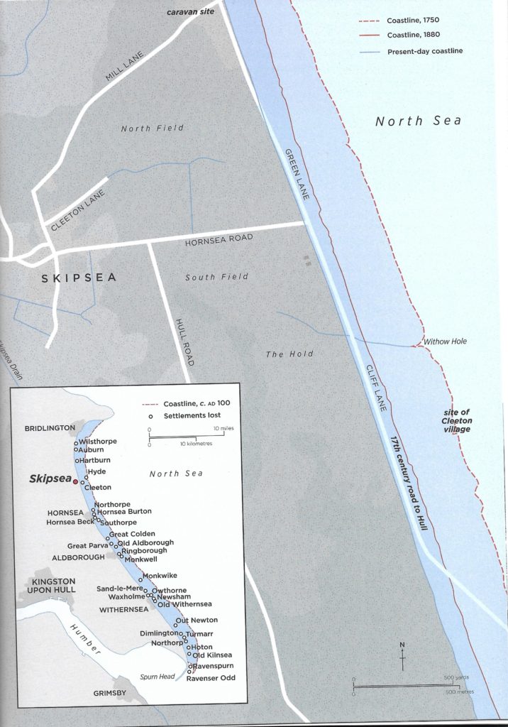
Turn the clocks back even further, though, to the age of Roman Britain and the land where Skipsea stands so precariously today, was nearly an hour or more’s walk from the sea. The settlement, which grew up around the castle and manor established in Norman times, would only become properly coastal in around 1600. From the Old Norse, skip, for a ship, and saer, for a lake, its name derived from a mere whose waters once ran through a series of navigable channels out into the River Hull. is was subsequently drained, leaving an expanse of fertile silt that made good farmland. Lingering traces of the area’s formerly extensive agricultural activity can be spied in the dilapidated outbuildings, ruined shacks and rusting machinery on the gone-to- seed plots that dot the areas between Ulrome and Skipsea.
Since the 1930s, when holiday chalets were built on the cliffs at Southwick Farm, Skipsea has been a coastal destination, providing a quieter and more modest offering for seekers of fresh air, briny water and other distractions than the region’s main resorts at Hornsea and Withernsea. Visitors, who arrived in greater numbers with the erection of caravan parks in the 1950s and 60s, have been attracted by the austere beauty of the landscape here, where shallow, grassy flatlands abruptly end in crumbly russet-brown cliffs that reach down to sandy beaches and the ever-lapping waves of the North Sea. But composed of clay left over from the glaciers that retreated at the end of the last ice age and when the North Sea retained the quality of a muddy swamp fed by the Rhine and the Humber, this soft boulder coastline has been eroding almost from the moment of its creation. Today it is officially Europe’s fastest-eroding coast. Current rates put retreat between Skipsea and Spurn Point at 1.5–2m (5–61⁄2 ft) a year, but in more recent times there have been moments of far more rapid and violent collapse with as much as 20m (65 ft) of cliff disappearing on one or two occasions overnight. Cliff collapses have rendered what was once the main road further south into the Sand-Le-Mere holiday park at Tunstall out of bounds while other road closures due to erosion mean that the residents of Green Lane in Skipsea can only access their properties from the rear. Some residents blame the construction of certain sea defences along the coast at Mappleton, Withernsea and Easington for exacerbating the situation by channelling waters in their direction. But while schemes are in place to improve defences as well as accepting a degree of ‘sustainable’ decline, with the sea already predicted to rise by a metre (3 ft) in the next hundred years, Skipsea’s continued existence is far from assured.
*
We have three copies of Atlas of Vanishing Places to give away on tomorrow’s newsletter, kind courtesy of the publishers. Make sure you’re signed up to our mailing list!