As our run of annual Shadows and Reflections draws to a close, Alistair Fitchett looks back over 2021.
What a tremendous show Detectorists is. I’ve just re-watched it in its entirety, and it has given up yet more pleasures. It’s also had me digging out the terrific Landscapes of Detectorists collection of essays that Uniformbooks put out in 2020, which in turn makes me want to go back and watch the show all over again. Well, there are worse loops to be stuck in.
As I am sure you recall, the show ends with Lance giving us a little monologue about how detectorists are time travellers. It’s a lovely touch, for of course the entire show is at least in part about the ripples of history resonating through landscape, inveigling their way into the souls of anyone remotely receptive to the energies. As detectorists would aver, it’s an addictive fascination, and we are all looking for our time machines.
I’ve found my own this year in the form of the Ordnance Survey Six Inch maps of 1888-1913, available to peruse for free thanks to the National Library of Scotland. It’s an astonishing resource, and whilst Other Maps Are Available, there is nothing quite like the exquisite detail on this six-incher. Now I learned very early in my teaching career that not everyone can easily visualise three dimensions from two and that not everyone can therefore make much sense out of maps. If, however, you are blessed with this skill then I cannot recommend strongly enough the pleasures to be found exploring this particular time machine. A word of warning though: Don’t expect to get any meaningful work done.
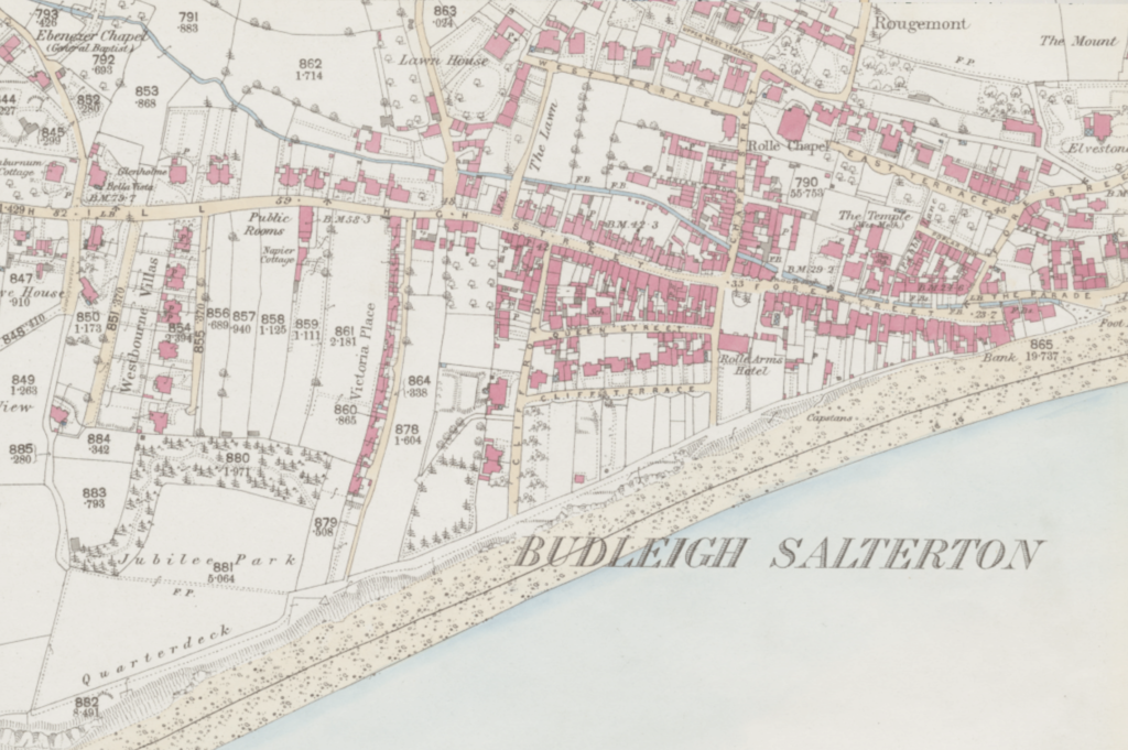
My own use of this Time Machine began in Budleigh Salterton on the Devon coast and arose out of research for a Golden Age style detective novel to be set in the town and its environs. Surrounded by old postcards and fed by the tremendously funny wartime memoirs of Joyce Dennys (you can read all about those on the Unpopular blog), I initially planned to familiarise myself with the locations of various hotels, Country Houses and possible routes that murderers might take through country lanes. Rather rapidly, however, I simply found myself drawn further and further into the turn of the 19th to 20th century landscape captured by the cartographers. Talk about rabbit holes…
In this era in Budleigh then, The Rosemullion Hotel has yet to be built at the end of Cliff Road, whilst its eventual, inevitable transformation into retirement apartments is a century or more in the future. Meanwhile, at the other end of town, past the coastguard station and where the War Memorial is as yet a distant, tragic necessity, we can still see the outline of the Blueberry Downs boarding house with its views across the various mud flats and saltings of Ottermouth. The bunds built by Napoleonic Prisoners of War are resolutely in place, of course, reclaiming as they have done for some seventy years or so, an expanse of formerly tidal flood plain. The town’s cricket ground has yet to move to these plains and still sits just above East and West Terraces, themselves still separated by the little Rolle chapel and its grounds. The endless arguments taking place on social media groups about the pros and cons of the return of these flood plains to the tidal river are, thankfully, unimaginably distant.
Fans of trains will still see the Exmouth and Salterton branch line curving around Copp Hill, the station and its cattle pens clearly marked in black ink. If we close our eyes, we can see the white painted pebbles on the bank proclaiming that ‘The West Is Best with Budleigh Salterton’ as a locomotive steams slowly past. The cutting and bridge over to Greenway Lane might still be there today, but otherwise all has been overtaken with houses. A quick switch to the 25 inch map of 1873-1888 (a brilliant time machine in its own right, it sadly only covers the South West of England, and perversely doesn’t include Cornwall) predates even the existence of the Budleigh branch line. In this landscape the curve of Station Road has yet to plough through the thin strip fields that stretch out from Moor Lane to Greenway, whilst the parkland of The Green is still made up of the parcelled fields of Little Knowle. Just to the west of this the gloomy, deeply hewn holloway of Dark Lane marks the edge of the Park House grounds. A perfect spot for murder, perhaps.
Back up on the cliffs, meanwhile, the Sherbrook Chine is well defined by the draughtsman’s delicate lines, though in the future the pathway down to the beach will have long been closed off due to the erosion that still regularly brings significant falls of read earth tumbling from the cliffs. The denouement of that still unwritten novel takes place along these cliffs, at the edge of what the map tells us was known as The Quarterdeck on the periphery of Jubilee Park.
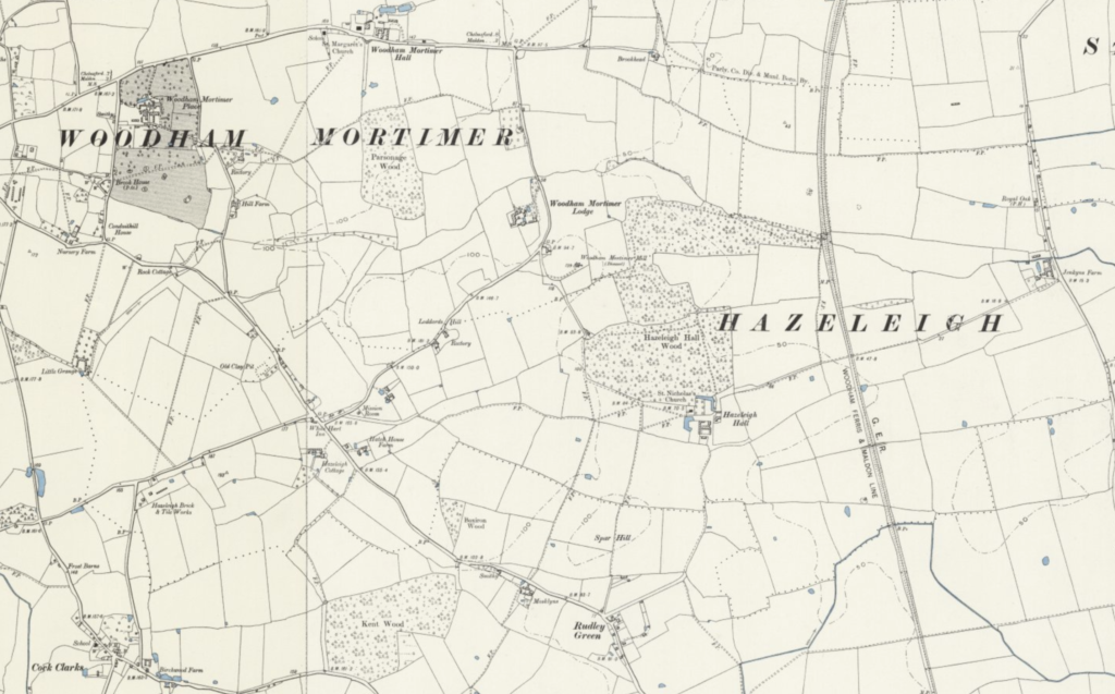
Nipping across country to the eastern coast of England and the land of The Detectorists, meanwhile, brings more delight. A glance at the map pored over in the pub by those wonderfully sketched characters reveals an intriguing blend of truth and fiction. The real town of Maldon has become Danebury (lifted from the real Danbury, one assumes), whilst Hazeleigh has become Hazeham and Mundon is more obtusely reconfigured as Crouchleigh. In this part of our Six Inch time machine map the addition of pale blue colouring helps to identify waterways, reservoirs and ponds, some of which remain although many appear to have been filled and ploughed into fields in the intervening century. Intriguingly, on the peripheries of The Decectorists’ semi-fictional (or partly factual) map, real place names remain intact. This blending of fictional and real placenames is also strangely rife in Golden Age detective fiction, so it feels remarkably appropriate here to see that Langford, Ulting, Woodham Walter and Purleigh really do exist. All are to be found in this time machine as the 19th Century eases into the 20th too, ready to welcome us as we mentally excavate the treasures of Spar Hill. We might even bump into Mackenzie Crook when we are there.
*
The fully zoomable OS One Inch map of the UK from 1888-1913 can be found on the National Library of Scotland website.
Other maps and overlays are available. The publishers accept no responsibility for productive hours lost immersed in the treasures held within.