In Edinburgh, Tamsin Grainger spent 2025 on a quest for a hidden river.
This year I have been looking for the Granton Burn in Edinburgh where I live. It began with a New Year Resolution to get to know the area better through planning a series of walks. What I needed was a good map. The February date coincided with the Festival of Terminalia, an annual celebration of the Roman god of boundaries, Terminus, on the 23rd. If I found a chart showing the boundaries, maybe I could get a measure of the place, define it better and identify its features. I was curious to discover who lived there before me, who the indigenous species and people were.
It was clear that the Firth of Forth estuary was the northern perimeter, and contemporary maps showed Ferry Road, a main east-west traffic artery, as the southern. However, nobody seemed to agree where the eastern and western edges were. Local organisations such as the Community and Parish Councils provided plans which differed. Street and building names that included the word ‘Granton’ were spread over a wide area, some to be found in neighbouring zones. Turning to historical documents, I discovered that the Wardie and Granton burns — Scots for small river or stream — were listed, but where were they? Not on my phone app, that was for sure.
There is an old map showing the City of Edinburgh in colour with Granton in white as if it barely existed. Only a number of thread-like lines depicting fields, one or two boxes denoting properties, and some grassy tussocks and tree shapes can be seen. There was once a castle, the website for the existing garden and dovecot told me, but in 1544 the English invaded and it was sacked. I had very little to go on.
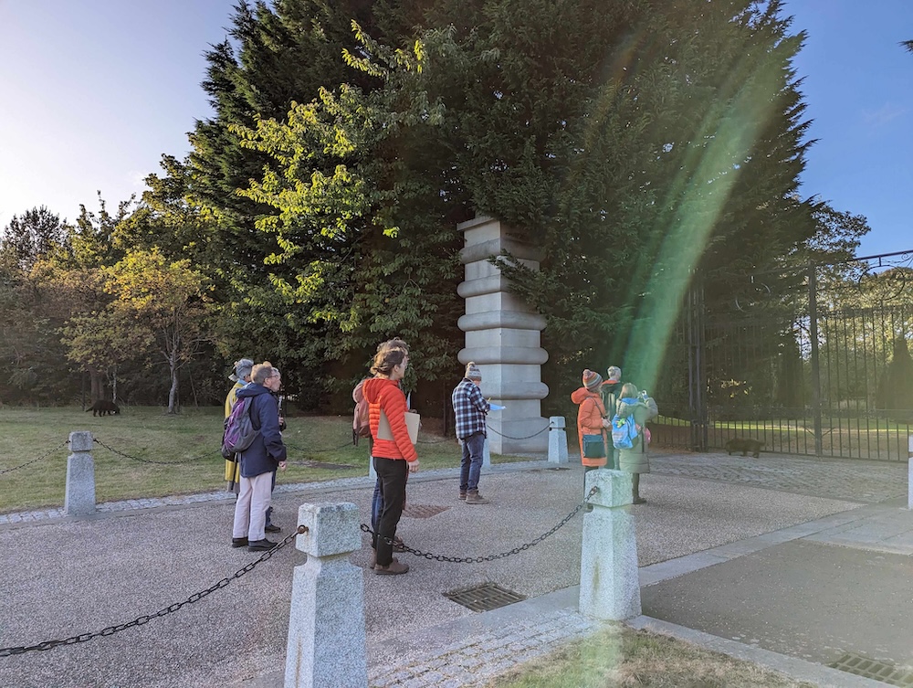
A Granton Community walk – outside Caroline House
Here is where the community walks came in useful. Local people who joined me on my search said that although the Wardie Burn cannot be seen, its route roughly followed the current A903. I had noticed musty, damp smells near where that road meets the end of mine. I could occasionally hear the shrieks of foxes and other small creatures coming from somewhere unpenetrated by street lamps. My walking companions confirmed, yes, the Burn used to run in a dell there between two slopes, maybe still does. Now I knew the eastern limit.
The Granton Burn remained elusive.
On my March walks, when I was close to what I guessed was the edge of the area, I started asking people, “Am I in Granton?” When they shook their heads and said “No, hen,” I would enquire, “Do you know where it is?” Everyone had an answer; it was just that their opinions did not tally. In the end I collated the replies and results of my research and drew my own map using pencils and ink on an old roll of wallpaper. Then I mounted it in an exhibition at Granton Hub, the local community centre, to prompt further discussion.
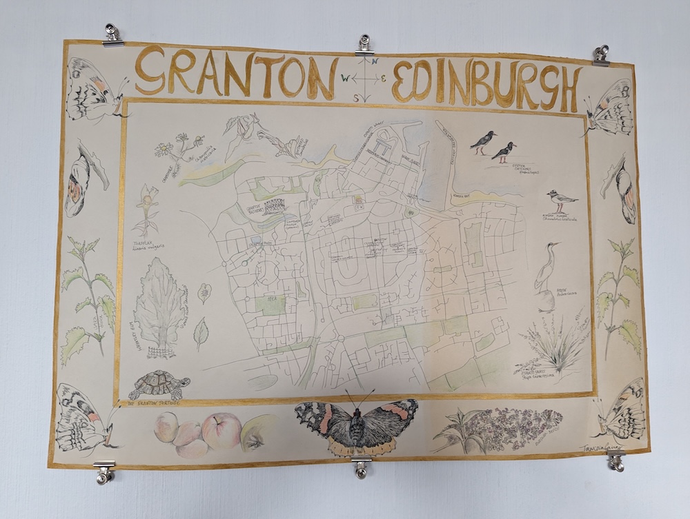
Granton Map by Tamsin Grainger. Pencils and ink on wallpaper. March 2025
Like most cartographers, I used a bird’s eye street-view, and influenced by the ancient maps I had lying around my studio, I surrounded it with illustrations of other-than-humans I had met on my walks. The red admiral butterfly is shown in various stages of its development with the nettles and buddleia it thrives on. Our resident heron is there, together with a pair of oystercatchers from the Bay, and also the Wheatley Elm from my garden. This particular elm tree is ideal for Granton for it can cope with salt and high winds.
One chilly day in April, on a community walk, we stopped outside the gates of Caroline House, a private residence down by the sea that dated from 1585. A group member told us a ghost story associated with it: An overnight caretaker had made his rounds in the early evening, checking no-one else was present. All night he heard the distinct sound of furniture being moved upstairs and could not sleep. When someone came to relieve him the next morning, they went up to the floor above only to find that nothing had changed. It has never been explained and people love to speculate. While I was listening, I spied a fountain of water through the fence, coming out of a grassy knoll. What was its name? No-one knew.
As the months went by, my walks skirted around this property. I discovered that a drain on the side of the Firth of Forth regularly overflowed with Spring rains, flooding the road as if the water was making a dash for the Brick Beach, a nearby strand dumped with building materials. When I explored the beach, I found what looked like a cast-iron pipeline in the sand, half hidden by seaweed. Could it be spilling out water, and if so, where did it come from? My appetite truly wetted, I retraced my steps, hesitating at the gravelly side-entrance to Caroline House and peering into the gardens before creeping in undetected.
I found a burn pouring over a stone sill and rushing under a low-arched bridge. It flowed beside the house and, further on, at the bottom of some rickety steps. Slipping on the slimy wood, I clutched the handrail to save myself and, at a tilt, was delighted to spy a colony of over-wintering ladybirds all cuddled up close in a nook underneath. Following the water’s flow, I came to the end of the garden and what looked like gate posts. Two square stacks of red stone were set into a wall glowing in the evening sun. Though the space between the stacks was bricked up, I could climb up and see the Brick Beach beyond. Turning to make my way back up the slope, I was assailed by angry cries. I had been discovered.
I offered profuse apologies and gently persuaded the owner I was not threatening. I felt she really wanted to tell me about the history of her home. “This is the Sea Gate and that is the Granton Burn,” she told me. I was very happy to hear it, and asked, “Do you know where the source is?” I had recently walked the Braid Burn from its Portobello mouth, further along the Edinburgh coast, to the source in the Pentlands (my writing is part of an Art Walk Porty publication here). I assumed the Granton Burn must also originate there. “No,” she replied, “I think it rises on Corstorphine Hill.”
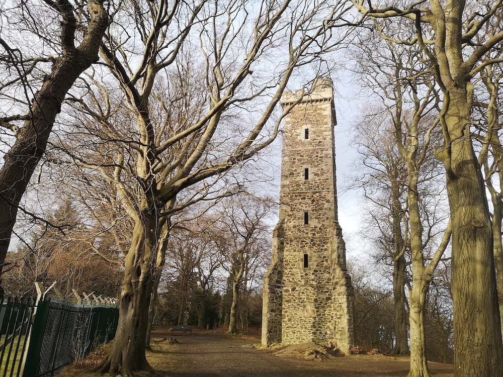
Corstorphone Hill, the Scott Tower
The owner let me out through the front entrance, and waved goodbye. I noticed how squelchy the grass was underfoot. In fact, it was always sodden here whatever the weather. Staying with the juicy noise, I passed the Scottish Gas building and the lights were on. Shut for quite a few years, I could see a security guard at the reception desk, so smiled and gestured. He let me in. “We’re getting ready to re-open after the flood” he said, and I remembered that an inundation had been responsible for staff leaving; the Burn must run underneath. I continued on towards Forthquarter Park where there is a man-made canal and a new sign had been put up since my last visit: ‘Please Look After Your Granton Burn.’
During the summer, I took more walks through Forthquarter Park, watching the moorhens negotiate the bullrushes and proud-necked swans swimming amongst irises. Silver birches were coming into full trembling leaf and gulls were lined up on the railings. A ‘Footpath’ marker pointed me between Waterfront Park and West Granton Road, and there was an unexpected lochan of sparkling water with a warning — ‘Deep, Beware.’
After this, the trail went dry.
As Autumn began, I received an invitation to speak at the Scottish Historic Buildings Trust (SHBT) Winter Lecture Series on the Edinburgh Coastline. This was the excuse I needed to pick up my project again. I visited the National Library’s wonderful map store and scoured for water sources. With the support of the librarians, I found wells and springs, sluices, another reservoir, and filtering beds, all between Corstorphine Hill and Caroline House. That weekend I put on my walking boots, took a bus to the foot of the hill and started to search for the origin of the Granton Burn. I believed it had served many of the industries I knew proliferated along the Forth Estuary in the 18th and 19th centuries: paper, coal, steel wire, and ink, to name a few.
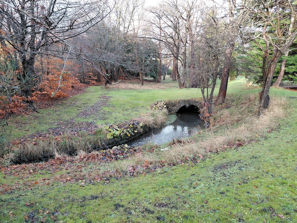
The Granton Burn in the grounds of Caroline House
Starting up the zoo side, I quizzed a dog walker for signs of the burn. We were standing beside a Scottish Water unit which was buzzing and humming. “Oh yes,” she said, “there are wells just on the other side of the Scott Tower.” After locating them inside circular pens overgrown with brambles, it was easy to follow a gully in the undergrowth. I ignored my scribbled maps and almost flew down the hillside knowing I was onto something.
When I came to a road and stopped to get my bearings, rain was starting to drip onto my notebook and phone. Something else was wrong too: trying to align myself with Caroline House seemed to be impossible. I was not on the right side of the hill. It looked likely that I had been lured by a different burn altogether, one that was running towards Crammond Island, also on the Firth of Forth, but nearer the famous bridges. River though it must have been, this was not the one I was searching for.
Back up the steep incline I trudged, meeting a helpful woman with a baby strapped to her front who took me home to consult her husband. He gave me a paper map, but it did not mention the burn. Later, I spotted a man in a sodden anorak looking up and asked him if he knew the area. He said he was a tree surveyor and after a short explanation of my quest, explained that he was born in Granton and his father still lived there. “The Wardie Burn runs under his garden. If you stand outside the Co-op on Boswall Parkway after the rain you can hear it.”
Back at the apex of the hill, I was fed up. It was four hours since I had arrived and according to the street map, it would take me the same time to get back home. Perhaps it was impossible to detect water below ground, even if I had spent a lot of time in its company. I ate my picnic and looked around. The land dropped steeply off to the left where the vegetation was lush. I got out the map I had sketched at home and it showed squiggly blue lines at the bottom where the old maps said Craigcrook Castle used to be. There had been a pump and it was definitely facing in the right direction. I had nothing to lose.
It was raining hard and the daylight would not last long. As I descended the steps, there seemed to be a watery flow in the earth — or was I imagining it? Through the fence, the grass flattened out and a horse was grazing. Suddenly, I stumbled into a hole, nearly falling forwards onto my hands and knees. Clear water was running over my feet; water with vitality. I waded on, energised now, despite soaking socks. It was as if I could feel a sort of magnetic pull from underneath. I sprang from bank to bank over a ditch, lost the trail but was able to find it again quickly. Water-loving plants and grasses, damp-loving fungi, the outward signs were clear, and inside I had a strong feeling too. I had a sense of the water being grateful. It seemed weird, but it really was as if the burn was wanting to be found, was glad to be beside me.
Onwards, and sometimes there was a path and sometimes none. It was unfamiliar territory, but I was not lost. Every time I looked at the compass, I was on-course. I passed a pool, a little creek, went behind a school and out of trees through back gardens. A lane led to a side-street and a main road and then I was in built-up Blackhall where men were on their way to the mosque. As daylight began to dwindle, I was still heading for the known sections when I crossed the familiar Roseburn Cycle Path, realising with surprise that I had never thought to look for a Rose Burn, if there was one*. Manoeuvring between bungalows and blandly designed housing schemes with not a lawn in sight, I kept my attention below ground.
After Pennywell, I came across Granton Mill, a development where a friend lives. In 2024, I had worked at the local history archive. No-one had known if there had been an actual mill there, nor which water it relied on if there was. Now I knew. I crossed Ferry Road into Granton, and trekked through the last blocks of nondescript tenement flats before regaining the reservoir. Ten minutes later I was on the sea side of Caroline House. It was no surprise to hear the force of the burn before I saw it, gushing along after the heavy rain.
As I write, it is the last day of December. I know now that most of the Granton Burn is underground, as many urban rivers — the Fleet in London, Farset in Belfast, for example — are. May East, international urbanist and author of What if Women Designed the City? advises us not to rely on old maps when navigating changing urban landscapes. Prompted by this, and the difficulty I had finding the river, I have embroidered my own, its stitches representing my walking steps. Though this year’s research has not been academically corroborated, this walk of faith seemed to be acknowledged by the Burn itself. As if it knew I was there and was pleased that I was paying it attention, it showed itself to me.
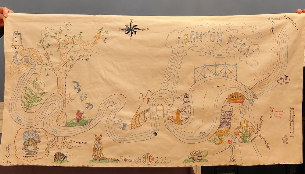
The Granton Burn, stitched map by Tamsin Grainger. Textile and cotton thread. December 2025
I chose to place the Burn at the forefront, and I matched the colours to the 1867 W. and A. K. Johnston Plan of Edinburgh and Leith, using simple running- and chain-stitches. It draws on my walking encounters, depicting a fox, a moth, chamomile, and oyster shells. There are also seabirds, tortoises, a pilgrim, and reminders of some of the industries that relied on the water. Presented at the SHBT Winter Series to accompany my lecture, From Hill to Sea, the map can be viewed at Riddles Court, Lawnmarket, Edinburgh.
*When I looked up the Rose Burn, I found that ‘the burn drained into Corstorphine Loch, originally a glacial lake giving way to a large area of marshland which was finally drained in the c17th.’ (Water of Leith Conservation Trust website)
*
Tamsin Grainger is a writer, bodyworker and walking artist living in Edinburgh. Visit her website here.