 The Gugh, courtesy of Gibson-Kyne, St. Mary’s
Words by Sue Brooks
There are warnings of gales in all areas except Trafalgar.
I leave the radio speaking softly to itself in the kitchen and negotiate the stairs in the semi-darkness. It is 6:10am. From the spare bedroom window I should be able to see across the Roads to the main island.
Rain hammers against the glass, driving through a grey mist. Beyond the land there is the darker grey of the sea, foam-streaked in white from long lines of breaking waves, each one adding to the plume of spray over Crow Rock Beacon. Perhaps the boat won’t come today. I send up a prayer that it won’t and go to wake up the children.
If it doesn’t, the next shopping boat will be the following Thursday. We need new shoes, toothpaste, library books. All these are important, but they can wait, I tell myself. Caught, as ever, on that tiny island, population 51, between pride and terror. The other island women will go. Some will take their children. In an hour or so they will be watching, dressed in their oilskins, for the first sign of bursts of spray taking a wide berth around the Beacon. Spray which is not in the sea’s rhythm, but the mechanical rhythm of a diesel engine sending a wooden hull crashing deep into the waves and emerging. Their husbands will drive them to the quay in an old van or the cab of a tractor and they will gather in the stone shelter and talk while they wait.
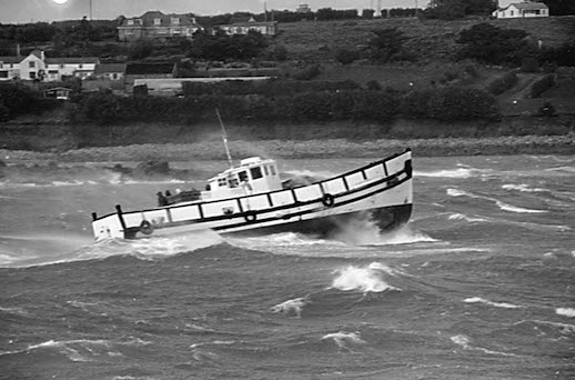
MV Fervent was built in 1944 for the Royal Navy as a motor launch, and bought by the Steamship Company in 1961. She was renamed Gugh after one of the smaller islands in the archipelago. She carries freight and passengers between the islands, but the emphasis is on freight. Passengers are expected to squeeze into any available space, and in bad weather they must be below deck in the saloon. This means climbing down a steep metal ladder from the wheelhouse into a small room next to the engine where 10 or 12 people can sit on benches with their backs to the wooden planking of the hull. Clinker or carvel? I used to know the virtues and disadvantages of both – one overlapping, the other abutting – and I seem to remember the wall I leaned against in the Gugh, being smooth. Carvel built from wood as solid and impermeable as railway sleepers. A comforting thought in a storm.
It’s 9:45am. In the small wheelhouse the skipper stands on the wooden box, peering through green water sluicing over the window. Always immaculate, even in heavy weather gear. A man of few words and bad moods. Tommy the mate, beside him, barely able to reach the sill of the window. He is small and bandy-legged as if he has spent his life at sea. Tommy’s oilskins are torn and seem at least one size too big, but he’s smiling and friendly. It isn’t necessary to be compatible. The work is what counts, and having a good boat. The Gugh is that sort of boat, I am certain.
We sit in the saloon, the engine labouring alongside. Conversation is impossible. The 6 inch portholes, one each side, are mostly below water, and always there is the sound of the wind screaming and waves pounding the hull inches away from our heads. At some point when the skipper judges it to be right, the Gugh has to turn through 180 degrees, broadside for dangerous minutes to Atlantic seas, in order to run for the shelter of the quay. After what seems like hours, I wait for that moment to arrive. The engine will be at full throttle. The boat will lurch violently to port. I will need to brace my feet against the metal runners on the floor, and hold the children tight. The moment comes, and passes. The engine steadies to a more regular beat. Soon it will be over.
And it was. One shopping trip among many taken in the winter months in the years we lived there. No one spoke and no one was sick. The journey took one and a half hours instead of the usual forty minutes. Tommy threw over the heavy fenders as we came alongside the quay. He stood on the granite steps while the boat rose and fell several feet in the swell. Each passenger, each shopping bag, pushchair and child was handed across. See you later. 3:30. We won’t go without you. Perhaps the wind will have abated by then, even just a little.
The Shipping Forecast was the prelude to every attempt to leave the island. And now the Shipping Forecast issued on behalf of the Maritime and Coastguard Agency at 0500 hours on Thursday January 24th 1969. The area forecasts for the next 24 hours Viking. N. Utsire. S. Utsire. Forties……..I screened out as the voice continued: not caught by the poetry at all. It became urgent and important at Plymouth. Plymouth. Biscay. Finisterre. Sole. West veering Northwest 6 to 8, occasionally Severe Gale 9 in Sole later. Moderate or good. Sole was the centre of our area, or we were the centre of Sole. I had no idea how or where it existed, as a rock or a line drawn on an Admiralty chart, only that if gales were imminent in Sole, we would not be going anywhere. A bad weather relationship you could say. Casual, but surprisingly enduring and forever linked to those pre-mains electricity, pre-telephone days when the radio was our only contact with the outside world.
Years later, when we had left the islands, all gone our separate ways, the relationship took on a new aspect. A spell of insomnia reunited me with the 0520 voice. A different voice which often changed, male or female, sometimes relaxed (in fair conditions) sometimes speeded up (in strong winds), always calm and controlled, as I remembered it to be, the Captain on the bridge prepared if necessary, to go down with his ship. Captain MacWhirr in “Typhoon,” saying regretfully I wouldn’t like to lose her. I began to pay attention. I photocopied a page from a library book and pinned it to the kitchen wall. As the voice intoned, I followed the course on the map. The Sea Areas I had known in the past were areas 14 – 19, the outer south western reaches of the archipelago. Not just the mysterious Sole, dominant weather lord of the islands, but a much larger archipelago, The British Isles, with 31 Sea Areas. Cromarty. Tyne. Forth. Dogger. Fisher. German Bight……..Lundy. Fastnet. Irish Sea. Shannon. Rockall….Bailey. Fair isle. Faeroes. Now I heard the poetry and the music. Now I was falling under the spell.
I flew to America for the first time. I saw the white surf of the Atlantic breaking over the rocks off the west coast of Ireland. I was homesick and conjured up the map on the kitchen wall. Viking. N. Utsire. S. Utsire.Forties. Cromarty. Off by heart. I had the Sea Areas off by heart, all 31 of them. On the return I watched for the white surf as eagerly as a long absent lover, and had to wipe away the tears.
I paid more careful attention. I learned to understand the meteorological code where soon means weather expected within 6 – 12 hours of the start time of the forecast, and occasional means weather appearing for less than half the forecast period. The number of words in the forecast can never exceed 370, and the time allocated at 0520 and 0048 is 11 minutes exactly. Within these parameters, the voice must maintain a measured tone and pace. I felt I was gaining intimacy. No longer in the outer reaches, I was exploring the beauty of the whole configuration.
I saw there was an inner structure, like a play with three Acts. The Shipping Forecast starts in the Sea Areas, which can be just that – areas of sea such as Sole for example, now revealed to be south of Ireland and west of the north coast of France, or they can touch other land masses, such as North and South Utsire off the coast of Norway. Act 2 is the Reports from Coastal Stations, which can be on land, but equally moored offshore. They have none of the cadences or romance of the Sea Areas. Tiree Automatic, Sandettie Light Vessel Automatic, Greenwich Light Vessel Automatic, Leuchars, do not make the heart sing or inspire lines such as Carol Ann Duffy’s
Darkness outside. Inside the radio’s prayer
Rockall. Malin. Dogger. Finisterre.
And there is a third Act, easily overlooked. The Forecast has thrown its net wide over the Sea Areas, and now draws it closer, passing the Coastal Stations and reaching The Inshore Waters. The words resonate like a psalm. The Inshore Waters. And now the inshore waters forecast issued by the Met Office on Tuesday February 22 2014 at 0500 for the following 24 hours. The general situation – an area of low pressure to the northwest of the United Kingdom will continue moving southeastwards, filling slowly. These waters extend from the coast up to 12 miles off shore and are intended to provide information, in the language of the Meteorological Office, for “wind-powered vessels and small coastal craft”. This was the archipelago as I had never imagined it before. I added a new map to the kitchen wall and committed it to heart. Cape Wrath to Rattray Head. Rattray Head to Berwick upon Tweed. Berwick upon Tweed to Whitby. Whitby to Gibraltar Point. Gibraltar Point to North Foreland………Mull of Galloway to the Mull of Kintyre. Mull of Kintyre to Ardnamurchan Point. Ardnamurchan Point to Cape Wrath. A necklace for the beloved from headland to estuary to peninsula to sea loch The desire grew for even greater intimacy. I would visit The Inshore Waters, I would count the beads of the necklace. It is a tribute in progress.