A tale of middle aged folly, told in two parts.
Day 1. Ivybridge to Okehampton
Words and pictures from West Country correspondent Alex Smith
There was a change of itinerary agreed upon just the night before setting off. What had first been planned as a manageable three or four stopper would now be completed in two long days. There was a certain amount of logic to our thinking: we would travel more quickly with our lighter panniers; the cost of one night at a bunkhouse would easily off-set the 3 nights’ camping fees that we would have been prey to on the longer trip and, of course, it would be an adventure, more in keeping with how we feel about our longer jaunts, more traveller than tourist, more pathfinder than short vacationer.
The Dartmoor Way is billed as a recreational route that will take you around the peripheries of the moor, dropping in on market towns and moorland villages, mostly navigated on the smaller, less travelled lanes with the occasional longer easy section on the disused rail and tram lines that define this region’s industrial past. The option is always there to drop in on individual sections for shorter scenic rides or, alternatively, the time-rich could take a leisurely 5 to 7 days to complete the whole Dartmoor Way in one long trip. We, in an act of sheer folly fed by bravado and middle-aged late evening confusion, were now committed to doing the whole thing in two days.
If you get out a lot in these latitudes, few of the stretches of the Dartmoor Way in your closer orbit will be completely unknown to you. It is the way of the leisure route planner that shorter local sections will be joined together with others of their ilk to forge the longer routes that make it onto the National Cycle Network map. Some of these longer routes also share the same physical space as others, meaning that sometimes a walker or cyclist will join with others on completely different trajectories for short distances before they part at the next way-marker or the one after that.
The common route north to Okehampton from Yelverton, is a case in point. The posts here bear the aubergine and green roundel of our chosen Dartmoor Way and, up until Tavvy, also host the green circular way-markers of Drake’s Trail (a newer route between Plymouth and Tavistock). These markers then find themselves jostling for position with the blue and white numbered way-markers of the Sustrans Route 27 (an older route from Plymouth to Ilfracombe, and an adventure of ours from the not too distant past) and, just to punish the unwary glance of the tired and inattentive expeditioner, on occasion they also bear the markers for those travellers heading across your path, their arrows bearing them off on other tangents, their signage above or below yours and often looking very similar, perhaps only differing by a simple digit or two. And thus is a network created, but not, as yet, a Harry Beck on the horizon to make a better sense of it all.
It all started off fairly well. The winding country lanes out from Ivybridge through Bittaford to Wrangaton gave way to moorland lanes at Shipley Bridge and an even more moorsy feel on the stretch to Buckfastleigh. From there we had a short leg to Buckfast in the sun (and a slight misreading of the route that had us heading up towards the Abbey, only to be put right by a drunk on a verge who we decided had opted to go straight to the source) and then we were on our way again, this time to Ashburton and from then on to Bovey Tracey. There were some fair old hills on the way, particularly up to Rushlade and again on the way up to Bag Tor. A steep freewheel down wooded lanes from the tor gave way to the biggest climb of the day so far, up to Birchanger Cross, a definite get-off-and-push type hill. Then on to Ilsington and Saint Michael’s Church with its fine and picturesque lychgate and then through Brimley to Bovey Tracey, ahead of schedule and about one quarter of the way into our trip, halfway for the day. We lunched in Mill Marsh Park, sprawled over a curved concrete seating area decorated with ceramic tiles, our bikes propped on the ends whilst local kids, on their Easter break, mucked about by the river behind us in the spring sun.
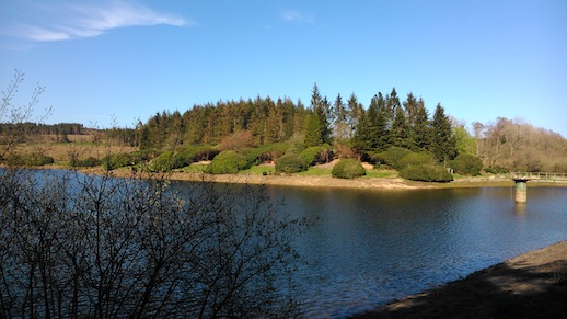
The section on the old Wray Valley railway track was easy going, but the uphill roads they led on to were a taste of what was to follow. Pushing uphill to Wreyland and then freewheeling down to Slade Cross (where we crossed the busy Bovey/Morton road), we started on what would be the blueprint for the rest of the day: steep uphill pushing, and lots of it. We pushed all the way up to Pool Mill, a good mile of the steepest, hottest pushing the area has to offer. There was then a short level relief on a pretty section that threaded its way through the three reservoirs of Trenchford, Tottiford and Kennick but, then, up again as it took us on a steady incline to Blackingstone Rock and then a short rise as it steered us up to Pepperdon Down and Moretonhampstead. We replenished our diminishing water supplies at the sports centre and headed up sharp hills again to Hospit Cross and Bughead Cross and Great Weeke before a final push up into the square at Chagford. It was four hours since Bovey and only thirteen miles covered. We were considerably behind our schedule and we collapsed by our bikes in the square outside the convenience store, drinking cold drinks from the fridge and dining on long-date pork pies.
It was a refreshing downhill from Chagford, to Factory Cross, but then, of course, an uphill around Gidleigh Park and a combination of uphills and level cycling past Wonson to Throwleigh, Sticklepath and Belstone before arriving at the Inn at about 9 o’clock, two hours late and twelve and a half hours since leaving Ivybridge.
More from Alex Smith here