A new series of posts following Tom Bolton – author of ‘London’s Lost Rivers’ and ‘London’s Lost Neighbourhoods’ – as he travels the coastline of the British Isles.
On a Friday night in late July, Jo and I met at Liverpool Street Station for an after-work train to the Essex coast. We had been walking the coast, on spare weekends and occasional bank holidays, for fifteen years – attempting to trace the edge of Britain and record it in ways we had never properly defined. We did not plan to stop until we had walked it all.
This impractical project stemmed partly from Andrew Kötting’s film Gallivant, released just as I left university in 1996 and moved to London. I was brought up in a village in the South Warwickshire countryside, in a triangle between Stratford-upon-Avon, Warwick and Leamington Spa. It was a place heavy with history and stasis, as far from the coast and its shifting tides as England can offer. The pull came from places with sharper edges: layers of hills to the west, where the border country climbs towards the Black Mountains, and the spirit-level horizons of the distant coast where the sea bends from view.
Kötting’s curious family saga had a satisfying logic about it. He simply travelled the entire coastline of Britain, taking his elderly mother and young daughter so they could get to know each other better. He careered around the edges, struggling to meet a schedule that was “full to overflowing”. We kept the concept but dropped the deadline. Progress was gradual, but by summer 2016 we had walked out along both banks of the tidal Thames from London and, in forays, around Kent, East and West Sussex, Hampshire as far as the Solent and the Isle of Wight. Drawn irresistibly to the modernist Midland Hotel at Morecambe Bay, we had also walked much of Lancashire from Grange-over-Sands at the southern edge of the Lakes, through Blackpool and the Fylde, to a curious world of dunes and golf courses at Lytham St. Anne’s.
Essex proved more involved, close to London but with a coastline apparently designed to deter the casual visitor. Multiple estuaries, mudflats, seasonal ferries, coastal reclamation, broken seawalls and MoD firing ranges mocked the promenades of beach holiday Sussex. The task required research and focus. Consulting 350 Miles, Essex coastal essays by Ken Worpole and flatland photographs by Jason Orton, we identified points of dereliction for reference and hidden narratives to study. We became regular Friday night visitors to Liverpool Street, pushing out along the Thames estuary past the Crowstone at Southend, marking the end of the river and the start of the North Sea. Crossing the empty Dengie Peninsula on a pilgrim trail and tracking along the wide Blackwater to Maldon and back, we reached the River Colne as the summer heatwave broke. We planned to walk from the Colne Estuary to Clacton-on-Sea.
Bishopsgate and Liverpool Street Station were full, everyone outside in white shirts, jackets off, crowds too large for the spaces they occupied. The station Wetherspoons, a Victorian railway hotel dining room with added fruit machines, had installed bag-searching bouncers. London seemed unsettled, labouring under a grievance from its referendum snub a month before. Politics could not be as easily ignored as usual, and no-one was sure when, or whether, normality would return. Coastal escape was a temporary solution.
We took the Norwich train, with young, prosperous couples lining up pre-mixed G&Ts on their way to North Norfolk summer parties. At Colchester, we climbed the hill to find our stopover, an unlikely vegan B&B. The town was handsome in an Essex manner with wide market streets, fine red-brick Georgian town houses, a scattering of timbers. Its history was intimidating but caveated, the oldest recorded town in the country, Cymbeline buried in the local park. The city gates had been relocated within a system of underpasses, guarded by a 1970s cement memorial to local physician and physicist William Gilberd. He had been a Colchester man and Elizabeth I’s personal doctor, but was also responsible for discovering that the core of the Earth was made of iron and the planet was therefore magnetised. This insight re-orientated all subsequent journeys to magnetic north, guided by Gilberd’s theory.
Colchester was also well-supplied with strip bars, top-shelf corner shops, army surplus warehouses, tattoo parlours and made-over SAS pubs selling craft beer. The town’s main 21st century addition was Firstsite, the ‘golden banana’ arts centre which, plagued by delays, had missed its moment and opened during peak austerity. That morning police had been scrambled across the town centre after reports that the suspects in a kidnapping attempt at RAF Marham in Norfolk had been sighted near Colchester’s army base. The local paper, the Daily Gazette, had described them as the most wanted men in Britain.
The bus to Brightlingsea left late, while the driver squared the County Controller who, he explained, did not mind where the buses ended up as long as they left town. The route took us through the University of Essex campus, where novelist Lars Iyer had depicted a post-‘68 generation of philosophy students who had tried to “politicise their despair” by reconnecting to an Old European intellectual heritage. The university had attempted to distract from its three brutal towers with new buildings with coloured facades, keen to be liked.
Research had indicated a treacherous route along the Colne estuary. While the OS map showed a footpath crossing Alresford Creek, online walkers reported a wade across the mud not to be attempted without the right equipment. There had been a railway bridge. Brightlingsea had a Station Road and a Railway Hotel, but nothing to catch. The Crab and Winkle Line from Colchester to Brightlingsea, closed in 1964, was now more myth than fact. The nickname was contested, used by two other redundant lines – one in Kent, and the other across the Colne at Tollesbury – but the common factor was a lack of trains.
We settled on the ferry across Brightlingsea Creek, to the marshes beyond. Brightlingsea was still a port, but so discreet that we had to ask for confirmation. Discretion was the motivation when, in 1995, the livestock industry attempted to open a new route for live animal exports to the Continent. Abattoir closures in Britain had caused cattle and sheep to be transported on ferries, in grim conditions, for continental slaughter. When public opinion caused ferry companies to back out, exporters sought less visible alternatives. The Battle of Brightlingsea lasted for most of 1995 as protestors, the large majority of whom were local women, prevented ships from loading while riot police piled in. The stand-offs ended when the exporters cut their losses, and soon afterwards the saga was forgotten amid the BSE outbreak.
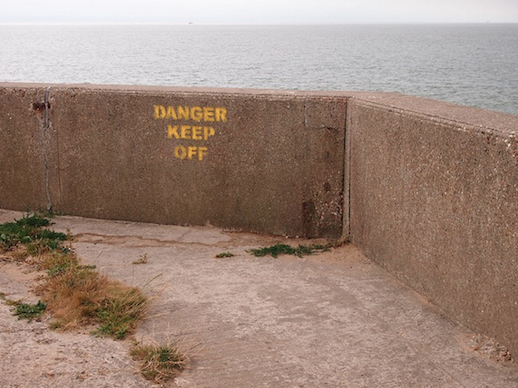
The port was obscured by a large riverfront development, looking like every other marina on the south coast, and the jetty carried “No crabbing beyond this point” signs. Brightlingsea Creek lay wide, grey and mirror-still. The ferry to Point Clear was a two minute trip, if that, in a tiny landing craft that drove straight at the shingle beach and dropped its prow. The two ferrymen told us that when the big ships stopped coming, churning the river bed with their screws, the port had silted up. They hoped that dredging would bring back the business. In the meantime, they recommended a visit to the Point Clear Martello Tower, but warned us about venturing beyond: “It’s all dark beyond there”, they claimed.
Point Clear was indeed mostly Martello Tower, and a tiny café that served teacakes, kebabs and bacon, spelled “Becon”. The sea wall took us past caravans and a chalet with press cuttings taped over its windows, expounding conspiracy theories about the European Union. There was no continuous coast path, and we had to divert across a potato farm with glamping facilities to reach the sea wall.
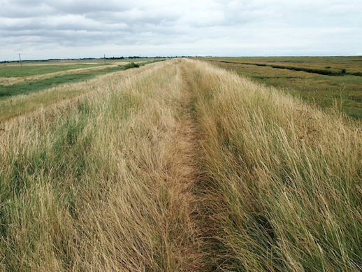
At last the coastal marshes opened out, a lipped concrete causeway snaking through tidal lagoons, the wooded rim of Mersea Island to the west. Sails dotted the mouth of the Blackwater, white and rust-red. We were somewhere on the coast, standing on the hard boundary between land and sea, gazing out along the Colne saltmarshes towards where Dunkirk was hidden from us by the curvature of the earth.
*
Look out for Edge Walking: Brightlingsea to Clacton-on-Sea, Part Two in the coming weeks.