A series of posts following Tom Bolton – author of ‘London’s Lost Rivers’ and ‘London’s Lost Neighbourhoods’ – as he travels the coastline of the British Isles.
Words and images by Tom Bolton
Our expeditions beating the bounds of Essex had recommenced in late Spring 2016, after an intermission of several years. We first struck out along beyond the Thames Estuary in 2011, walking from Southend-on-Sea across the Dengie Peninsula, a revelatory land of wide skies, long dykes and sea walls. It was a mysterious place which, although easily reached by train from Liverpool Street, was remote enough to be the chosen location for the closest nuclear power station to London at Bradwell-on-Sea.
The Dengie was unmistakably ancient and very much ignored, more important to the Romans than to 21st century Britain. The peninsula was occupied by small villages and farms with names from deep antiquity – Dots and Melons Farm, Coney Hall, Bacons, Blackbirds, Twizzlefoot Bridge. Its isolation was symbolised by the lonely, barn-walled St. Peter’s Chapel, the objective of a pilgrimage route which pressed due east across Essex into the rising sun until it reached the sea. St. Peter’s occupied the site of the lost Roman coastal fort of Othona, where St. Cedd, a Saxon monk from Lindisfarne, had later founded what was described as ‘a cathedral’. This too had become forgotten, and had been used as the barn it resembled, until restoration in the 1920s.
Five years on, in May 2016, we had taken up our walk from where we had left off, at the village of Bradwell-on-Sea, where the Dengie ends and the long Blackwater Estuary begins. The intervening period had taken us on along many other coastal paths – West Sussex, Hampshire, the Isle of Wight and much of Lancashire – while Essex had taken a back seat. But the Dengie had lingered in our minds all along, and nothing since had equalled its strangeness. After spending a night in Burnham-on-Crouch – Wallasea Island visible across the river, where the soil bored from under London for the Crossrail tunnels was being taken in barges to reshape the coast – we were in position for a bus ride over the marshes to Bradwell. From there we intended to walk the south shore of Blackwater Estuary to Maldon, and at Maldon we would turn back out along the north bank. The estuary was ten miles long, but significantly more once every meander of the squirming coast path was paced out, and it would take us two full days to measure its length.
During the Spring of 2016 we had little inkling of the cultural and political nervous breakdown just around the corner, aware of looming votes in Britain and the USA, but confident we knew which way the tide was running. The signs we saw during our two days beside the Blackwater only later seemed to have any larger significance. As we wound the lanes on a single decker, it became apparent that the horizon had changed since our last visit. The Dengie had grown a cluster of wind turbines which, a resident told us, funded the village hall. Bradwell, missing the nuclear economy that had wound down with its decommissioned reactors, had pragmatically traded in its assets.
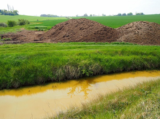
We turned our backs to walk west, heading inland with the broad Blackwater to the right, low-lying farmland to the left, and the sea wall weaving precariously between. Just past Bradwell the sea wall had been breached several years earlier, reflooding fields and returning them to salt marsh. The Environment Agency had committed to ‘holding the line’ between Bradwell and St. Lawrence for a further ten years – after that, the landscape was up for grabs.
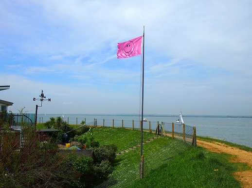
The path skirted inland around the new marsh, but returned to the coast at the caravans of the Waterside Holiday Park and the village of St. Lawrence. Until the early 20th century this had been Ramsey Island but The Wade, the channel that cut across the marsh, had been closed with a new sea wall. St. Lawrence was a new village, bungalows built boat-shed style as the mid-century boom charged the Essex economy and scattered new residents from inner London out into the periphery. The Stone, however, was old – a landing place which, with its oyster beds, had been the entirety of the village one hundred years before. A sailing club now occupied the empty beds and a pink smiley flag flew on the point, as though sending a subversive code to passing yachts.
On the point, beside the massed blue, pink and white sheets of the Marconi Sailing club, was a lawn with an Edwardian house in the distance. This was Stansgate Hall Farm, home of the Benn family, bought by William Wedgwood Benn, a Liberal MP who joined the Labour party in the 1920s, becoming a Labour peer and a minister in the Attlee government. His son, Tony Benn, had inherited the title Viscount Stansgate after the death of his elder brother in the Second World War. He had famously instigated a change in the law in 1963, allowing him to renounce the title in order to become an MP. He had, however, retained Stansgate Hall Farm, where he lived until his death in 2014.
Beyond, Steeple Bay Holiday Park was jet ski territory. At high tide Mayland Creek seemed to stretch impossibly far, washing over acres of what the map insisted was land. The machines spouted and barked, scoring wakes across the sheltered inlet and out onto the Blackwater. Peewits dipped and dived. The entire landscape had settled down to mud level, leaving only the sea wall high and dry. Mayland and Maylandsea, two adjacent villages, were covertly prosperous. Inconspicuous at the foot of a deep shifting creek, a small grid-iron of dead-straight 1960s avenues, a marina and a row of waterfront villas were a perfect hideaway. In one of the most isolated villages in the South East, a silver BMW coupé was essential equipment to eat up the long Dengie lanes.
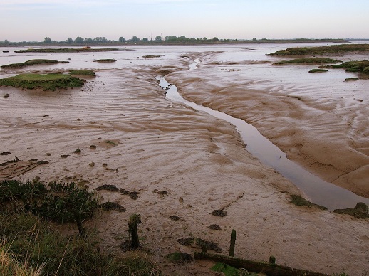
Winding around the saltings, the path crossed into an empty quarter. Dead flat, the estuary was sealed off from acid-yellow rape fields by a tall embankment. From the top, the vista over the Blackwater took in the opposite bank, two miles away, apparently uninhabited. All the action was on the river, boats under sail passing between Maldon and the North Sea. The ghostly forms of topsail barges, their full sheets mutating from dark red into black as clouds slid over, tacked through the river roads.
To the west the Blackwater channel narrowed, splitting into two creeks as it approached Maldon, passing either side of Northey Island. Owned by the National Trust, it could only be reached from a causeway across Southey Creek. The sea defences that had kept the island dry had been opened, a deliberate decision to create new tidal marshes. The sea wall was breached during the 1953 North Sea Floods which washed away the defences on the west side of the island, and three quarters of the island had been reclaimed by the sea. The tumulus marked on maps at the northern tip of the island was now inaccessible, submerged under the saltings.
Northey was also a site of great historical importance, the location of the Battle of Maldon, fought in 991 on the causeway leading out to the island. The battle, fought between Saxon men of Essex under Earl Byrhtnoth, and Vikings led by the Norwegian Olaf Tryggvason, is the subject of one of the oldest surviving poems in Old English. It tells how the Viking raiders, sailing up the Blackwater and landing on Northey Island, were trapped at the causeway by Byrhtnoth’s men. The tide, which “came flowing, flood after ebb”, or “flod æfter ebban” in the original, kept the armies apart. However, the Earl’s sense of honour gave him away. He allowed the Viking forces, at their request, to cross the causeway for a fair fight. The “sea robbers” broke the Saxon shield wall and three men hacked Byrhtnoth down beneath eagles and ravens “eager for carrion”. The Saxons, themselves incomers, were swept aside by a fresh wave of continental invaders. The battle site, under an arching, grey Essex sky, was sombre, and the eagles and ravens departed.
The first evidence of Maldon itself was the Marine Parade Recreation Ground, a busy park on the edge of the town. Families bought ice cream in a long queue at the café, and children ran along the riverfront. The sea bathing pool was closed – ever since, we later discovered, a man had drowned while swimming some years earlier. A group of teenagers drove an ageing Volvo slowly up and down the playing field, hanging out of the windows and climbing on the roof. No-one seemed particularly surprised when one, misjudging a leap, kicked out his own windscreen.
Maldon’s real centre was not the high street at the top of the hill but the Hythe, where the town met the river. Here pubs and boatyards jostled on the wharf, the solidity of the Hard contrasting with the soft mud shaped by the retreating tides, every edge rubbed away leaving only smooth, sinuous forms. A bronze statue of a thin, sword-wielding Byrhtnoth commanded the river. Maldon was the home port for the red-sailed barges which returned from their estuary trips and lined up along the quay. The flat-bottomed barges had been designed to work the tidal Thames and Medway estuaries, in as little as three feet of water, carrying sand upstream for building in London. They were redundant by the end of the 1960s but the Cook’s Yard fleet, which had operated since the 1890s, still ran outings from Maldon. The Thames Match, said to be the second oldest sailing race in the world after the America’s Cup, had been successfully revived. The race ran from Tilbury out along the Thames Estuary to the South Barrow Buoy, and back to Gravesend, testing the limits of vessels projected from another time.
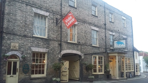
Maldon itself was handsome in the North Essex manner, with flint-spired churches, a Georgian high street and a pocket town hall. The Blue Boar, a substantial coaching establishment, flew a prominent red ‘Vote Leave’ flag, the first we had seen since the Referendum campaign began a few days earlier. The Leave side of the argument was entirely invisible in South London, and until we reached Maldon we did not even know what their posters looked like. The oppositional public declaration jolted us back to the role of this seemingly peripheral place in shaping the national future.
Maldon was a town built on river trades that had long-since died. Its solid, confident architecture hid a level of unease not immediately apparent. A man in a dirty coat waited for the Salvation Army shop to close so he could settle down in its doorway. It was Saturday evening but the town was quiet, except for a posse of young men and women carrying sound systems on their shoulders, strutting down the middle of the road in a bubble of high volume garage, carrying with them an air of menace. Their shouts echoed along the narrow 18th century side streets as they marauded back to catch the last train. The owner of the B&B where we spent the night claimed they came down every weekend from Basildon. We would be back soon, to shadow our steps along the north bank of the Blackwater and, perhaps, to gauge its significance in the national narrative poised to roll out around us.
*
See previous Edge Walking posts here.
Tom Bolton and The Museum of Walking will be hosting a tour of Ratcliff and Limehouse, London’s first port and its first Chinatown, on Wednesday 15 March. More info/tickets here.
Tom Bolton on Caught by the River/on Twitter