The latest in a series of posts from Tom Bolton – author of London’s Lost Rivers and London’s Lost Neighbourhoods – as he travels the coastline of the British Isles
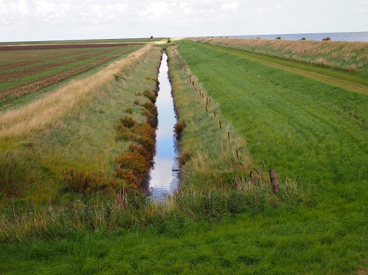
Unwilling to leave the Essex coast until we had achieved some sort of full stop, we made plans to return to the Dengie. Spread between the estuaries of the Crouch and the Blackwater, the Dengie Peninsula was an area of marsh reputed to be the most remote place in Southern England. It qualified for a place in Robert Macfarlane’s 2007 book The Wild Places, an attempt to locate surviving wilderness within the British Isles. Like much of the Essex coast, The Dengie consisted of low-lying farmland drained by dykes and defended from the sea, but it was different. This was Essex on a different scale: a slab of land fourteen miles from north to south, sparsely populated, featuring an ancient, remote chapel, a nuclear power station and, at least to the casual eye, little else.
We had walked the Dengie five years before, when the idea that became a walk around the rest of Essex had started to germinate. It had provided the perfect escape from a city obsessed with the London Olympics, and now it promised refuge from shoddy Brexit displays and third-rate politicians. We remembered it as vast, spectacular in its loneliness and simplicity, with only a path, the sea and the sky. Pronounced with a soft ‘g’, as we discovered through trial and error, it was a place from a fever dream, a northern version of tainted, Dengue marshes. Daniel Defoe, in his ‘Tour Through the Whole Island of Great Britain’, reported a story that a ‘strange decay of sex’ was found in the Dengie where young women, coming down from the uplands to marry farmers, succumbed to ‘an ague’. The ague had been common in Essex throughout human history, once disappearing in the twentieth century. Now it was feared it could return with a warming climate.
Returning at the tail end of the summer, to take advantage before the light evenings failed, we took the train to Burnham-on-Crouch. For a wilderness, the Dengie was strangely well connected. A direct train from Liverpool Street would deposit you on its doorstep in an hour, a situation locals had seemed keen, on our last visit, to keep under their hats. Burnham was also a remarkably pretty town, like many of the places we had visited on our walk. General knowledge of Essex ended at Brentwood, with the occasional excursion to Southend and Clacton, but the towns of Eastern Essex were little-known delights. Burnham had a Georgian high street equipped with everything from a pocket cinema to a pet grooming shop, and a waterfront lined with timbered inns, a crowd of boats bobbing at anchor in the estuary. On the quay, teenagers had gathered in a circle to test their rapping skills, and their incantations drifted over the Crouch towards the far shore.
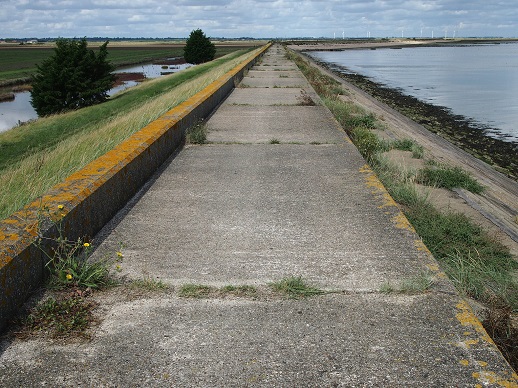
The following morning we walked out on to the quay and headed east. Soon we passed the Royal Corinthian Yacht Club, an art deco pavilion which carried a cryptic notice warning of possible explosions overheard. It was sailing weather, fine and clear, with a light breeze stacking and dispersed towers of white cloud to the west. We left the boats behind, except for a single sail which matched our walking pace for a full five miles. Then we left the dog walkers behind and, within fifteen minutes of setting out, there was only us and the small boat tracking us out on the river. It would be a five hour walk before we met another person. The path stretched out to a vanishing point, balanced and perfectly level on the crest of the sea wall ringing the Dengie.
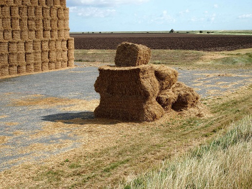
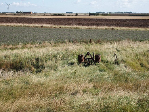
Walking soon became an act of weightlessness, and we felt suspended somewhere between land, sea and air, and suspended in time. It seemed to slow, as landmarks in the far distance not only refused to move closer as we marched towards them, but retreated in opposition to our steps. Ordinary features seemed to have become distorted, appearing larger than they had any right to be. The first five miles took us to Holliwell Point, marked by what we were convinced was a large Second World War fort, typical of the fortifications found all the way along this coast. By the time it had stopped shimmering on the horizon and assumed a settle shape, it had shifted and become a vast stack of bales thirty feet high, the tallest structure for miles around. A smaller bale stack had settled in a sagging sculptural shape, accentuated by deep shadows, with the symbolic presence of a Paul Nash painting. This was no ordinary landscape.
To the south, on the far bank of the Crouch, unusually tall radio masts sat among a landscape as flat as the Dengie itself. This was Foulness, home to the Shoeburyness Firing Ranges and accessible only to the Army, where we had failed to make landfall during our coastal visits. What we first imagined was a church tower was visible too on the skyline, but it had a boxy look to it, as though the original had been replaced by a replica designed to deceive radar. The shapes on the Foulness horizon did not match identifiable structures, and we were unsure how to interpret what we saw.
The sea wall path made a ninety-degree turn to head due north from Holliwell Point, and the rest our journey lay ahead in a ten mile-long straight line, terminating at St. Peter’s Chapel. We also turned towards the aspect of the Dengie that had changed since our last visit. Silhouetted against the wide sky were two groups of wind turbines, nine close by on Dengie Marshes, nine more to the north on Bradwell Marshes. We had asked a Bradwell resident about these when we walked the Blackwater the year before, and she had seemed very relaxed, observing that they had funded the village hall and would not be there for ever. However, they had proved controversial with many, and dominated the skyline, their stiff shapes rolling in slow motion. More were on the way, with an application in for a third group closer to Burnham. They could not be ignored, and the empty appearance of Dengie had changed since our previous visit. Turbines, however, were easier to remove than a nuclear power station, and Bradwell-on-Sea appeared as a grey ghost box in the far distance, being decommissioned on a timescale that seemed to grow less certain as it progressed. The marshes laid everything bare. In a place where there could be no hiding and the ordinary seemed hyper-real, the outsize forms of the turbines made a sort of sense.
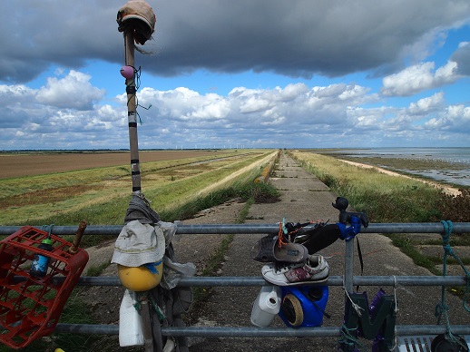
Somewhere on the outskirts of Bridgewick Farm, a gate across the sea wall had been hung with fetishes made from flotsam. Caps, shoes, bread crates, milk containers, plastic balls and toys had been scoured from the foreshore and tied in clumps to the gates. The marshes had their own version of the clootie well, an Environment Agency sluice where high tide detritus had been arranged as offerings to placate something or someone, somewhere. Robert Macfarlane had stayed here to find out what inhabited the Dengie night, lying out on the sea wall in his sleeping bag. We were keen to reach the safety of the Chapel before darkness trapped us in this parallel land.
The strangeness of the marshes is lodged in modern popular culture. H.G. Wells’ Martians landed here in War of the Worlds, appearing from the North Sea off Foulness and stalking across the Dengie via the tiny village of Tillingham. And Hitchcock is said to have taken inspiration for The Birds from a visit to the marshes. We spotted a distant line of people, the first since Burnham, gesturing rhythmically with white flags as they stalked the horizon. They were beaters, scurrying across a beanfield to keep their line straight, as the dismal pop of shotguns plucked waterfowl from the sky. It had been reported locally that the Dengie was under surveillance as a suspected location for illegal hare coursing. With a figure out on the marshes visible for miles, it would not be an easy place to avoid observation.

Our straight line became longer as the end approached, and the final mile stretched the furthest of all. Then we reached the chapel, red-roofed and grey-stone-walled. The Chapel of St. Peter’s-on-the-Wall was the second-oldest church still operating in Britain, after St. Martin’s in Canterbury. It had been founded in 654 by St. Cedd, a Saxon monk who arrived from Lindisfarne to bring the gospel to the East Saxons. The site he chose was the abandoned Roman coastal fort of Othona, much of which had now disappeared under the sea. The chapel was a barn-like space that had been restored from a ruin in the 1920s. There was a car park and, despite being at the remote edge, seemed the most familiar place we had been all day. Perhaps that is why we let down our guard, and made some casual assumptions about how easily we could find a cab to Southminster Station. We had forgotten just how few people lived out here, and how few taxis were required to serve their needs. Some considerable time later, after visiting two separate pubs for advice, trawling Bradwell for an elusive phone signal, and calling every taxi firm in East Essex, we located a ride from halfway across the county. The Dengie had repaid our expectations – remote and strange, shifting and otherworldly, and we felt sure this would not be the last time we walked this particular stretch of sea wall.
*
Tom’s new book, Camden Town: Dreams of Another London, is out now. We have five copies to give away on this week’s newsletter. Make sure you’re signed up to our mailing list before 11am tomorrow for the chance to win.
See previous Edge Walking posts here.
Tom Bolton on Caught by the River/on Twitter