Tom Bolton walks Norfolk’s rapidly receding coastline.
In our last walking trip of 2019 – documented for Caught by the River – we reached Happisburgh, on the fast-eroding Norfolk coast, fully intending to return as soon as the days lengthened and the first spring of the new decade arrived. The Norfolk walk is part of our long-term – very long-term – project to walk the entire coast of Great Britain. For reasons which scarcely need explaining, by the time spring came this was no longer possible. In common with most of the country, we spent four months watching the trees come into leaf from our window, and missing the freedoms we had taken entirely for granted – most of all, to travel where we chose.
We imagined, in particular, returning to the Hill House Inn at Happisburgh where we had ended our walk from Great Yarmouth. The pub was the ultimate coastal bolthole, full of clutter and associations. It sat on a doomed coastline where the sea swallowed the crumbling cliffs, and the village above, in greedy mouthfuls. Our never-ending coast walk (see also my book Low Country, about the Essex coast) is, as much as anything else, a way to pace and mark the passage of time. Imposing a system and making a route map provides a feeling of control over the unpredictability of living. In 2020 we needed this pleasant illusion more than ever before. As freedom of movement gradually returned and people were able to leave their houses without answering questions from the police, I refreshed the Hill House Inn’s Facebook page obsessively, trying to gauge what was happening in far-off Norfolk and when we could return. It was late August when their accommodation finally reopened, and we arrived to stay in their only room and continue our Norfolk walk.
The pub, a timber-framed building dating from the 17th century or earlier, is owned by the friendly Stockton family who informed us, amongst other things, that the original thatch remains, bizarrely, under the tiled roof which was simply installed over the top, and that beneath the back room carpet there is just a bare earth floor. There had been changes since lockdown began. Cluttered pictures and objects had been removed from the walls, apparently because they could not be sanitised. The pub belongs to the family of the late Lorna Sage. She was an elegant, rakish academic who taught literature at the University of East Anglia, where I took my English degree in the mid-1990s. She, and her ex-husband Vic Sage (whose Gothic fiction course was my favourite thing about UEA), gained unexpected fame at the very end of her life with her autobiography Bad Blood, published in 2000. Her book, quite as Gothic as anything I studied, tells the story of her dysfunctional parents and grandparents, and Lorna’s own teenage pregnancy which, in the early 1960s, was still quite beyond the pale.
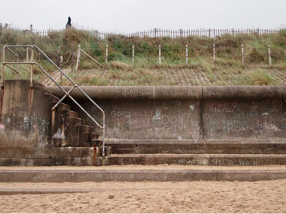
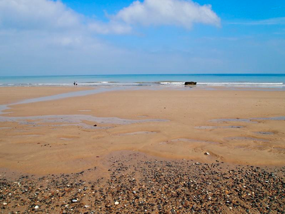
The beach showed signs of lockdown activity. Someone had chalked ‘Happisburgh is nicer than Spain’ on the sea wall, and a votive sculpture had been constructed on a breakwater from jetsam. We hoped it had been placed there to keep the virus at bay. Behind the pub were the remnants of a caravan park – weed-broken patches of hard standing and a locked toilet block – the rest of which had tipped into the sea. The pub, like other houses in the village, is within the ‘20-year line’ of projected coastal retreat and has no insurance value at all. Happisburgh is under the kind of existential threat, exacerbated by climate change, that only a handful of other places could understand.
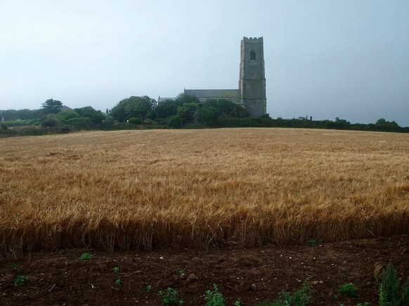
The next morning, there was low cloud over Norfolk, which came as a great relief. London had suffered under temperatures over 30 degrees celsius for more than a week, a sequence last experienced in the early 1960s. With no air conditioned offices for sanctuary it was a long, draining week in the city, and the mist on the fields held an otherworldly coolness. Happisburgh’s tall, square, flint tower rose above a field of ripe wheat.
This section of Norfolk’s coastline is more remote and less visited than the seaside and society resorts up the coast, for which we were heading. Bacton Gas Terminal is a giant complex of natural gas storage facilities, receiving gas from North Sea platforms with names such as Brigantine, Corvette, Galleon and Indefatigable. From Bacton, pipelines stretch across the North Sea to Balgzand in the Netherlands and Zeebrugge in Belgium, 140 miles away. The sandy cliffs below the terminal were defended, unlike Happisburgh, by a new beach which had been laid the previous year to defend the facility. It also protects the villages of Bacton and Walcott, although they are now prone to occasional sandstorms that bury cars and block roads. There had been controversy in 2019 over netting installed by the district council to prevent sand martins nesting in the cliff, partly removed after protests gained national attention. The cliffs were now clear and the burrows dug by nesting martins could be seen clearly. The birds preparing to leave for Sub-Saharan Africa were small and their flight liquid and graceful.
Intense thundery showers broke at Bacton, and we sheltered in the bar of an intact caravan park to contemplate the map, antiquity embedded in the countryside in the form of alluring labels in Gothic script. Norfolk is casually sown with astonishing medieval locations. Next to Bacton is Paston, home of the Paston Family who helpfully chronicled the upheavals of 15th century England in their preserved letters. Their concerns included quarrels with the neighbours which, during the Wars of the Roses, escalated alarmingly, leading to sieges and imprisonment. John of Gaunt’s House, at the nearby village of Gimingham, was inhabited a century earlier by the man who became the most hated figure in England when, as defacto ruler, he brought in the first poll tax. He is, however, better known by the elegy for England, words placed in his mouth by William Shakespeare in Richard II.
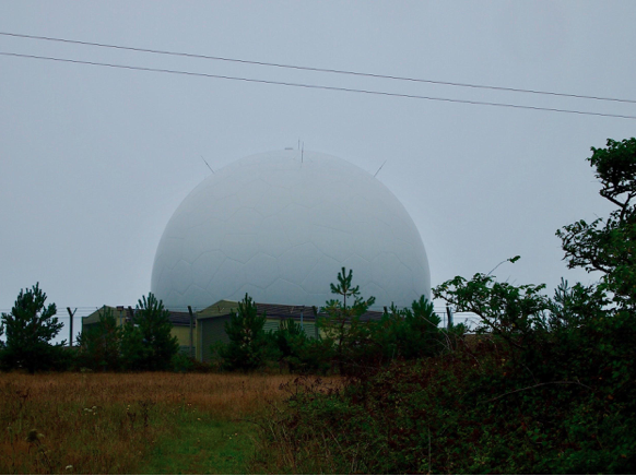
The cafe in Mundesley, where we had lunch, was on edge. Teenaged serving staff marshalled a small queue in the street, overseen by the owner. Instructed to hold infection at bay, they were clearly nervous about letting customers in. The anxiety buzzing around the ordinary followed us along the low cliff where a hang-glider drifted past, high above the beach and alongside the cliff path, only feet away, like an oversized drone. A sign on the cliff warned against hang-gliding close to the nearby RAF Trimingham radar dome, an eerie white sphere from 1970s TV sci-fi, that loomed in the mist. It cautioned that the microwave beams emitted by the facility could cause a ‘cooking’ effect.
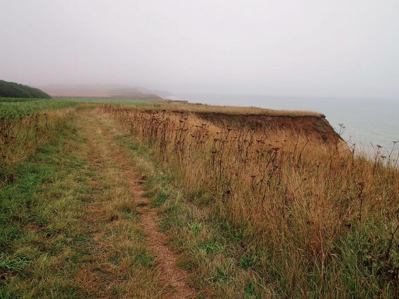
The open clifftop between Trimingham and Overstrand is scalloped by the sea. Entire sections have slid onto the beach below in reluctant heaps. The coast path, shown as a straight line on the OS map, was now a mazy route that veered to and fro, often too close to the edge for comfort. The people at the Hill House Inn had warned us to look out for ‘overhangs’ but, while clearly dangerous, they were by definition almost impossible to detect except in retrospect.
Eventually we crossed a collapsed concrete walkway which, while it appeared impassable, but was in use by a brisk possession of local dog walkers, and entered Overstrand, known as ‘the village of millionaires’. It is a seaside town with an Arts and Crafts atmosphere, partly provided by the works of architect Edwin Lutyens. Attention was first drawn to the village by 19th century theatre critic Clement Scott, who rhapsodised the place in bad poetry and branded it ‘Poppyland’, helping to bring it to the attention of wealthy Londoners looking for plots of land to build holiday homes.
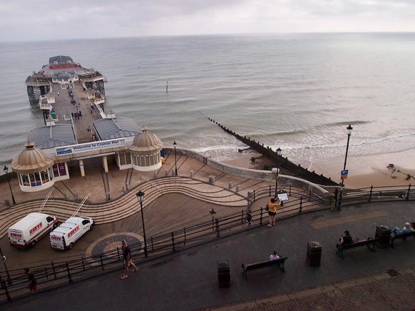
At Cromer, the low cloud descended into the tight streets and over the pier as dusk came. It temporarily pushed the town into its own slice of time, happily disconnected from the present for the space of an evening. We read about the lost town of Shipden, under the waves beyond the pier theatre. In 1087 Shipden-juxta-Mare was the seaside town, and Cromer was Shipden-juxta-Felbrigg. Only after sea level rise and constant erosion did the coast arrive at its current alignment, by which point Shipden was lost under the water. However, a rock that is occasionally visible at low tides is said to be the remains of St. Peter’s Church tower. In the 1880s a steamer ran aground on it and remained there until eventually dislodged with explosives, which are reported to have taken the top off the tower.
It rained that night, and the next morning the mist had cleared and a glorious August day was in full swing. We walked along the sand at low tide, below the shingle and the cliffs. West Runton, perched on top, is where my grandmother attended a long-closed girls’ school. It is not entirely clear how she ended up in Norfolk, as her family lived in North Warwickshire, but she was packed off as a boarder in 1919. It will, however, have been an entirely different atmosphere to the coalfields, where her father managed a mine, and probably a lot more pleasant. It must also have been a relief after the loss of three of her older brothers during the war.
In Sheringham, families were busy enjoying sandy summer holidays in perfect weather. The town centre was cheerful and busy, but then a horn sounded and kept sounding and an SUV rolled over the main junction and collided with a shopfront. The driver, who was quickly surrounded by first aiders, seemed to have collapsed at the wheel but had, through luck, driven through a gap on the crowded pavement. The vehicle rested against a thin column holding up the building above.
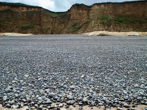
Beyond Sheringham, the cliffs sanks to their knees then disappeared altogether, and a shingle bank rose up in their place. The tide was still out, and the wet sands reflected the sky like a hand-leaded, 17th century mirror. The shingle was a universe of pebbles, uncountable numbers each a distinct shape and colours.
At Weybourne Hope there is deep anchorage just offshore and this, with the low cliffs, has made it ‘England’s achilles heel’, a spot feared vulnerable to invaders from the Spanish Armada onwards. The military museum on the cliff above the beach preserves the fearsome gun emplacements installed against a Nazi invasion.
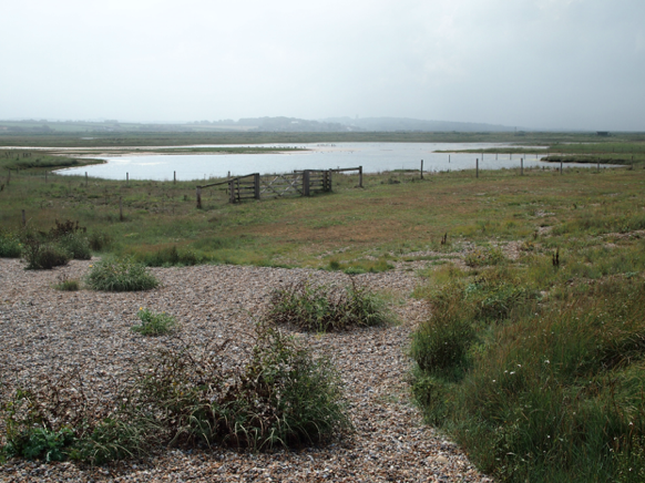
From Weybourne the view inland opened out into a flat, marshy landscape of fields, dykes and cows and, behind them, small villages with very large, square-towered churches. It looked unexpectedly Dutch. The flats were Salthouse and Cley Marshes, which opened out into Blakeney Point, a sand spit that is constantly extending itself westwards, where it tapers away into nothingness.
Upended railway sleepers protruded from the shingle bank, weathered into layers like puff pastry. It was impossible to tell what structure they had belonged to, but it had been so completely overwhelmed by the shifting coastline that it may as well have belonged to a lost civilisation. Walking west into the falling sun, towards a vanishing point, we were suspended in the final flares of summer.
We wound inland to Wiveton through Cley-on-Sea, tired by the packs we had carried over shingle and returning slowly to a more linear version of time. We left the next day, planning to come back before the summer was out, but we had reached the parts of Norfolk where accommodation is limited in normal times, and the small villages on this part of the coast were booked up for the rest of the season. We put the coast on hold, hoping another era shift would take place before our next visit.