In north Norfolk, Danny Adcock walks through the heart of the saltmarsh to reach Scolt Head Island — perhaps the same age as England itself.
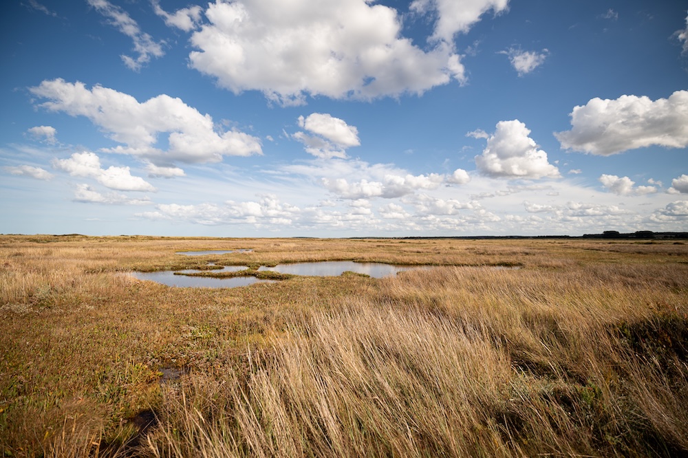
We’d left the car in a cul-de-sac off the North Norfolk coast road at Burnham Deepdale and followed a footpath between houses. Labrador Eddie ran on ahead, the promise of a swim enough to maintain his excitement. There was a messy, cluttered sky, clouds daubed here, scraped there. West, the Norfolk Coast Path takes you behind what are mainly holiday homes today, down to the harbour at Brancaster Staithe. East, the path rises onto a grassy, flat-topped trapezoid which serves to corral the sea, and eventually leads to another little creek-side harbour at Burnham Overy Staithe. I understand the necessities of sea defences, but they remain a mere addendum to landscape, a pallid caricature of the saltmarsh’s hidden labyrinth of channels, sweeping curves, hooks and inflections; a rationalist obstacle to the cursive, organic design of nature’s architecture. I paused briefly at this Anthropocenic crossroads and set off, not along the limen of humankind’s influence, but north, towards the heart of the saltmarsh, beyond which I could see the dunes of Scolt Head Island blocking my view to the sea.
The last time I wrote for CBTR I was in the north-west Highlands where the landscape speaks in epochs, and time inches along on tectonic plates. Scolt Head Island and Assynt seem irreconcilable as landscapes, antithetical in processes and time. Scolt is an example of what geomorphologists call an offshore barrier island, and it’s remarkably young in geological terms. There’s a debate as to its exact age, but the island we know today has perhaps existed for as little as 1,000 years. I’ve known the island as a permanent part of the landscape in my consciousness for three decades, but it’s difficult to conceptualise it within a timescale attributable to landscape features. There’s a Roman fort nearby, but the Romans were gone from there, and the rest of the UK, maybe half a century before the island’s first shingles were deposited. Around the time of the oldest estimate, Harold was defeated at Hastings. And only a century before that Æthelstan unified the Anglo-Saxons – Scolt Head Island may be the same age as England itself.
Heading north from the coast path we were soon on saltmarsh, and a short while later facing our first creek crossing. Eddie found thicker, cloying mud, and it soon squelched between my toes. A thumb-stick of some sort is a good idea on the marsh as it gives you extra leverage when extricating yourself from the knee-deep sections. The remnants of the tide were still being drained away at the bottom of the creek as a spoonbill passed right to left, in level flight, trailing lanky legs.
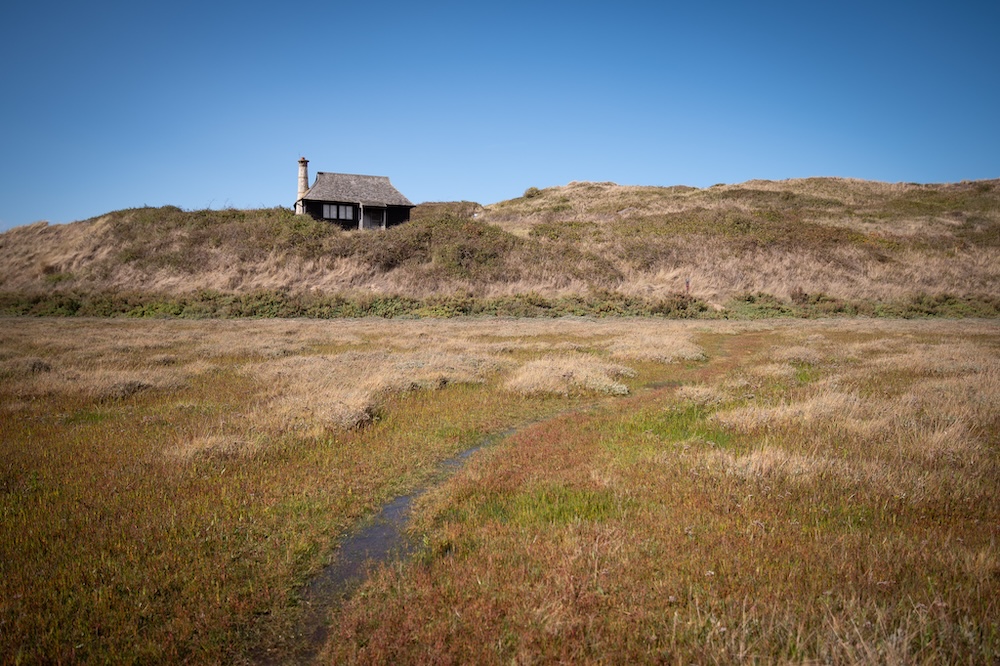
Once across, the path was less visible. The sea had left its lukewarm remnants in depressions and had filled footprints. Either side of the path tide pools – irregularly shaped, vegetation-free cut-outs randomly pockmarked across the face of the marsh – were brimming. Last week, before the spring tides, they’d been empty, filled with crazed patterns of mud. Thousands of sun-bleached, fingernail-sized crabs were caught like stars in galaxies of dried weed. The path continued alongside the Nod, a raised area of cord grasses and suaeda bushes. The Nod is high enough that your feet might have stayed dry at the top of the last tide. A National Trust sign jauntily displayed its ‘No Camping’ dogma. Perhaps they could incorporate this motif into letterheads and car stickers – The National Trust (No Camping).
Roger Deakin swam through one of the chapters of his book Waterlog at nearby Holkham. An inveterate water-lover, Deakin swam in the moat of the Elizabethan house in Suffolk he rebuilt himself, and described breaking down in a Tesco car park at the indignities suffered by the river Lark, funnelled through concrete for mere convenience. Inspired by John Cheever’s short story ‘The Swimmer’, he had the wonderful notion of swimming through Britain ‘To follow the rain on its meanderings… to break out of the frustration of a lifetime of doing lengths.’ Deakin considered swimming, walking and cycling to be subversive, nonconformist in their simple freedoms. Waterlog brims with obvious satisfaction in denying orthodoxy and officialdom, in a rejection of rules, exigencies and ‘No Camping’ signposts. He also had, if you’ll pardon the contradiction, a healthy disregard for health and safety. He went further east and swam at Stiffkey, just beyond Holkham, crossing Cabbage Creek on his way to the saltmarsh there. I imagine he would have been just as frustrated as the locals when in 2022 the National Trust, without warning, removed the bridge over the creek. This effectively cut off locals from the saltmarsh where for generations they’ve swum, birdwatched, picked samphire and cockles, fished or shot wildfowl, enjoying one of the county’s last, truly wild places. Not long afterwards a new, less permanent-looking, bridge appeared. Locals insisted it was the work of the faeries (the ones with access to planks and scaffold poles). A running battle then ensued while the National Trust cogitated for a year about cost, planning permission and feasibility. Each time an unofficial bridge was removed the faeries, under cover of darkness, would build another. Eventually sanity reigned and the bridge over Cabbage Creek was replaced. Roger Deakin died in 2006 after a short illness. I sort of think he would have preferred to use the faerie bridges.
Saltmarsh remains one of the few truly wild habitats we have in lowland Britain. It has neither the glamour nor attraction of uplands or mountains and is, understandably, much less frequented. Saltmarsh is a landscape of beyond, both physically and metaphorically, lying out of reach of our collective imagination.
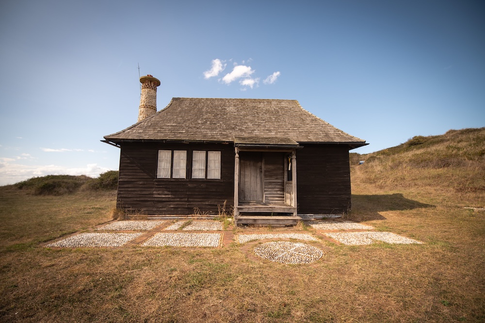
Of course, The National Trust does heroic work protecting our heritage and it’s partly thanks to them, as well as geography, that Scolt remains isolated and mostly untouched. In 1923 they bought the island for £500 with an additional £100 toward construction of a ‘hut.’ The hut was built to house the ‘The Watcher.’ Overturning this sinister-sounding epithet, the first Watcher was Emma Turner. Writer, ornithologist and pioneering wildlife photographer, she described herself as a vagabond of the reeds, living aboard a boat in the Norfolk Broads. Her photograph of a young bittern, neck and bill extended skyward, remains a beautiful image to this day. In geomorphologist J.A. Steers’s 1933 book Scolt Head Island, she wrote about Scolt’s need for protection. Apparently, tern eggs were regularly stolen for ‘domestic purposes.’ In 1922 there were 17 pairs of common terns. That number rose to 800 by the end of her two-year tenure. I came across the ‘formidable woman’ trope in several places while researching Emma Turner. She regarded her position as ‘nothing to make a fuss about,’ but that there was a fuss seems clear. The press labelled her ‘The Loneliest Woman in England,’ which she described as ‘misguided enthusiasm.’ My personal inclination is reinforcing stereotypes is never helpful, even where times, values and attitudes are out of sync. In the twenties a woman alone in this position would obviously have attracted comment, but I see no reason to reinforce such anachronisms today.
After another kilometre or so, having hopped a few small gutters that intersected the path, we reached the edge of Norton Creek. This channel gives Scolt its island status and is the most intimidating part of getting there. It was a spring tide, the highest of the month, which may seem counterintuitive when planning to cross a tidal channel on foot. The thing about spring tides though is that, as well as advancing higher on the incoming tide, they retreat lower on the ebb. This large dynamic range means it’s the ideal point in the tidal cycle to cross. However, it’s important to remember tides are wont to do the unexpected. Times and heights are predicted, not actual. Weather patterns at sea can mean tides significantly higher, earlier, or later than expected, however benign conditions appear. Although there is a right of way to the island, and in places it’s easily identifiable, it isn’t advisable to attempt crossing without some local knowledge.
Two and a half hours before low tide Eddie and I crossed Norton Creek, which runs west to east here, and east to west from the opposite end. Tide-meet must be somewhere in the middle, something to experience on the kayak at some point. A large crescent of mud is split by a tide-formed course four or five-feet deep leading north from the marsh for fifty yards or so to the bigger channel. Norton Creek opens into Brancaster Harbour, a large area of water protected by the outlying sand banks of Scolt’s western end. Caught between the light breeze and what was left of the current, a weathered blue dinghy circled its mooring buoy indecisively. With phone and camera in a waterproof backpack I wasn’t too concerned with how deep it was, although in the end it only reached my waist. Eddie was soon out of his depth and swimming. The channel bed is sand, which can be soft in places, and is sculpted into deep, uneven scallops which would have upended me a couple of times but for my trusty stick. We emerged below another National Trust sign confirming where we were. A couple of redshanks took flight, their pinging alarm calls echoing across the marsh.
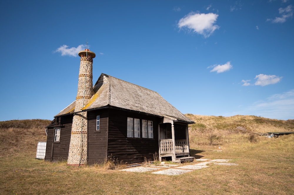
The best way to get to Scolt is the ferry from Burnham Overy Staithe. When tide and weather align, a jolly armada of dinghies, ex-Norfolk crab-boats and other assorted vessels can also be found readying themselves for the short voyage to the eastern end. Picnic hampers are stowed, sails flap eagerly in the breeze, halyards ting-ting-ting impatiently against mastheads, outboard motors idle contentedly. Gradually, as moored boats lift and swing into the current, the flotilla sets sail. Some adventurous souls catch the ferry, then follow the island’s long spine of dunes, or its deserted beach, and join the footpath which starts, or ends depending on your perspective, near the hut.
When we left the water and traversed the muddier banks up onto the island itself, bands of vegetation were formed in ranks. First, scattered, livid-green stalks of samphire whose clumps band together to form larger collections of plants about five inches high. Samphire is high on the saltmarsh forager’s menu. Boiled, with ground pepper and a poached egg, you’ve got yourself an eight or nine quid starter in local pubs. Many a tourist has paid through the nose for this delicacy while sitting not far from the chef’s free supply. Then the close-formed, pale pastel-greens of sea purslane, another marsh plant that crops up on menus.
On the island I made out a faint path leading north-westerly to follow, keeping a crescent of low dunes to our right. Up to the first channel we’d negotiated, the path was wide as a lane, and well-walked, while beyond it noticeably less well-trafficked and, once on the island, it ghosted in and out. Probably this represents the uninitiated marsh-goer’s bravado as they venture further from the mainland. The mud and the multiple channel crossings can make what seemed like a good idea at the time a less attractive proposition, while at the back of your mind is the ominous idea of the incoming tide.
According to J.A. Steers’s 1933 map of the island, we’d crossed onto Butcher’s Beach, with Missel Marsh to our left. Although there’s no beach now this recurve of dunes, which hook south-west then sweep back under themselves, would once have been Scolt’s most westerly point, now a couple of kilometres away. From an aerial view these recurves hang from the island like a row of Moorish scimitars. This one was well-fortified by a belt of waist-high suaeda bushes. A salt-tolerant perennial, it’s advisable to take care moving through them due to the rough, woody branches hidden below their foliage. Last year I met two ladies walking from the ferry whose shins were a mass of scratches and dripping blood after falling foul of the suaeda.
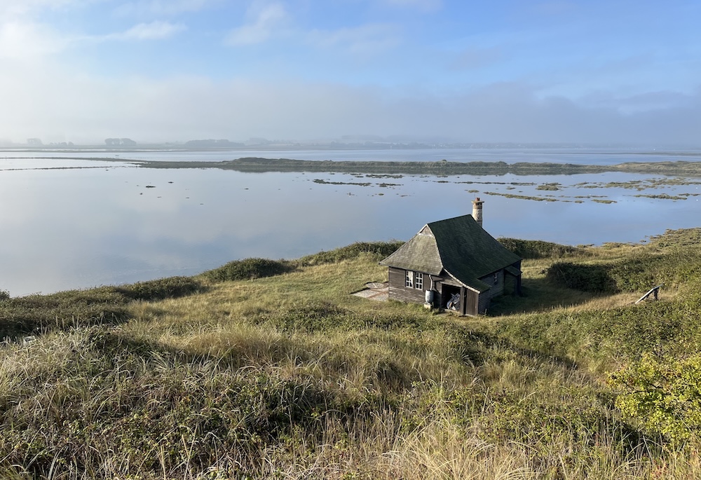
A low valley opened between dunes. We followed it, carefully, and emerged onto Hut Marsh. It was vibrant with colour. Most of the sea lavender had gone over, but here bumblebees still laboured amongst the purple flowers. Conversely, the samphire had started to turn, its flickering red spread across the marsh like an East Anglian dawn. Perched in the dunes above us was the original Watcher’s hut, but there was one more channel to cross. Waist deep, vertically sided, as if cut by navvies, the bottom was filled with cold, crystal-clear water pouring from the marsh over sand and pebbled riffles. It looked more chalk-stream than saltmarsh. These shingles form the bones of the island, onto which dunes and marsh are deposited grain by grain, sediment by sediment. Pioneer plants then follow, trapping further deposits, knitting grains into dunes and sediment into marsh.
We ate lunch on the hut steps where Emma Turner must have done, a hundred years before, looking back across Hut Marsh to the last, low roll of chalk hills we’d driven over a few hours ago. I couldn’t help but think of American poet Gary Snyder’s list poem ‘Things to do around a lookout,’ written while he worked as a fire lookout on Sourdough Mountain, and wondered whether Emma Turner had similar moments of ennui. Reading her 1928 book Birdwatching on Scolt Head Island, I don’t think she would have had time for boredom or melancholy. She had five terriers to keep her company and was never really alone for very long anyway – ten days the longest. Regular supplies were brought from the mainland, and many curious visitors in the first weeks and months of her tenure. Today there’s a modern equivalent of the hut further west where the now more prosaically-named wardens monitor the terns, but the hut is still used by visiting researchers.
We left the hut and climbed through blackberries shrivelled by drought. The dunes above must be three stories high at their peak, and the entire length of the island is visible from them. We ran down the steep, north facing dunes onto the beach, gaining momentum to that point where it feels like you’re trying to catch up with yourself, and you have to keep accelerating or it’s head-over-heels the rest of the way. On the beach, a group of cormorants were resting on the sand, drying their wings in the sun. Otherwise, birdlife was scarce, and I didn’t actually see a single tern. I sat with my back against a low dune with a flat edge sheered off by the sea, and watched the clouds slowly dissipating.
We didn’t sit for long. Unlike Emma Turner I didn’t have a system of flags to hoist in an emergency and, with an incoming tide to beat, it was soon time to leave.
*
You can follow Danny’s occasional landscape photography Instagram page here.